About Nigeria
Nigeria shares its international boundaries with the Republic of Benin to the west, Cameroon and Chad to the east, and Niger to the north. Towards the south, Nigeria is bordered by the Gulf of Guinea on the Atlantic Ocean.
The official language of the Federal Republic of Nigeria is English. Nigeria is home to an overall population of 170,123,740 (2012 estimate), with an area of 923,768 square kilometers (356,667 square miles). Nigeria is the most populous country on the African continent and the seventh most populous country in the world. Coal, tin, and crude oil are some of the important industrial products and palm oil, rubber, rice, cocoa, millets, and peanuts are the key agricultural products of Nigeria. The economy of Nigeria is one of the fastest growing economies in the world.
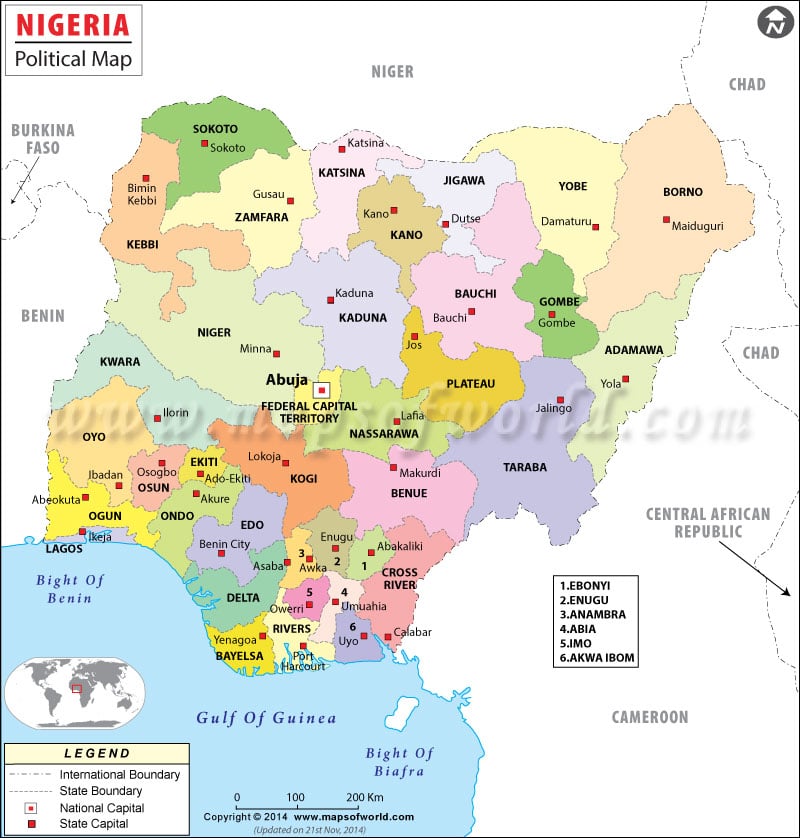
Nigeria Political Map
Nigeria is divided into 36 states and one federal capital territory. These political subdivisions are further subcategorized into 774 Local Government Areas (LGAs). The local government areas are governed by local government councils.
The states of Nigeria are as follows:
|
|
|
Top Cities
|
|
|
| State | Population | Area(km.) | Area(mi.) | Capital |
|---|---|---|---|---|
| Abia | 2,833,999 | 4,857 | 1,875 | Umuahia |
| Adamawa | 3,168,101 | 37,957 | 14,655 | Yola |
| Akwa Ibom | 3,920,208 | 6,788 | 2,621 | Uyo |
| Anambra | 4,182,032 | 4,761 | 1,838 | Awka |
| Bauchi | 4,676,465 | 48,197 | 18,609 | Bauchi |
| Bayelsa | 1,703,358 | 9,363 | 3,615 | Yenagoa |
| Benue | 4,219,244 | 30,755 | 11,875 | Makurdi |
| Borno | 4,151,193 | 72,767 | 28,095 | Maiduguri |
| Cross River | 2,888,966 | 22,112 | 8,537 | Calabar |
| Delta | 4,098,391 | 17,095 | 6,600 | Asaba |
| Ebonyi | 2,173,501 | 6,342 | 2,449 | Abakaliki |
| Edo | 3,218,332 | 19,584 | 7,562 | Benin City |
| Ekiti | 2,384,212 | 5,797 | 2,238 | Ado-Ekiti |
| Enugu | 3,257,298 | 7,560 | 2,919 | Enugu |
| Federal Capital Territory | 1,405,201 | 7,569 | 2,922 | Abuja |
| Gombe | 2,353,879 | 17,428 | 6,729 | Gombe |
| Imo | 3,934,899 | 5,135 | 1,982 | Owerri |
| Jigawa | 4,348,649 | 23,415 | 9,041 | Dutse |
| Kaduna | 6,066,562 | 44,217 | 17,072 | Kaduna |
| Kano | 9,383,682 | 20,389 | 7,872 | Kano |
| Katsina | 5,792,578 | 23,822 | 9,198 | Katsina |
| Kebbi | 3,238,628 | 36,320 | 14,023 | Birnin Kebbi |
| Kogi | 3,278,487 | 29,063 | 11,221 | Lokoja |
| Kwara | 2,371,089 | 33,792 | 13,047 | Ilorin |
| Lagos | 9,013,534 | 3,475 | 1,342 | Ikeja |
| Nassarawa | 1,863,275 | 26,633 | 10,283 | Lafia |
| Niger | 3,950,249 | 72,065 | 27,824 | Minna |
| Ogun | 3,728,098 | 16,850 | 6,506 | Abeokuta |
| Ondo | 3,441,024 | 15,019 | 5,799 | Akure |
| Osun | 3,423,535 | 8,585 | 3,315 | Oshogbo |
| Oyo | 5,591,589 | 27,036 | 10,438 | Ibadan |
| Plateau | 3,178,712 | 26,539 | 10,247 | Jos |
| Rivers | 5,185,400 | 10,361 | 4,000 | Port Harcourt |
| Sokoto | 3,696,999 | 32,146 | 12,412 | Sokoto |
| Taraba | 2,300,736 | 59,180 | 22,850 | Jalingo |
| Yobe | 2,321,591 | 44,880 | 17,328 | Damaturu |
| Zamfara | 3,259,846 | 33,667 | 12,999 | Gusau |
| Total | 140,003,542 | 911,519 | 351,938 |

 Wall Maps