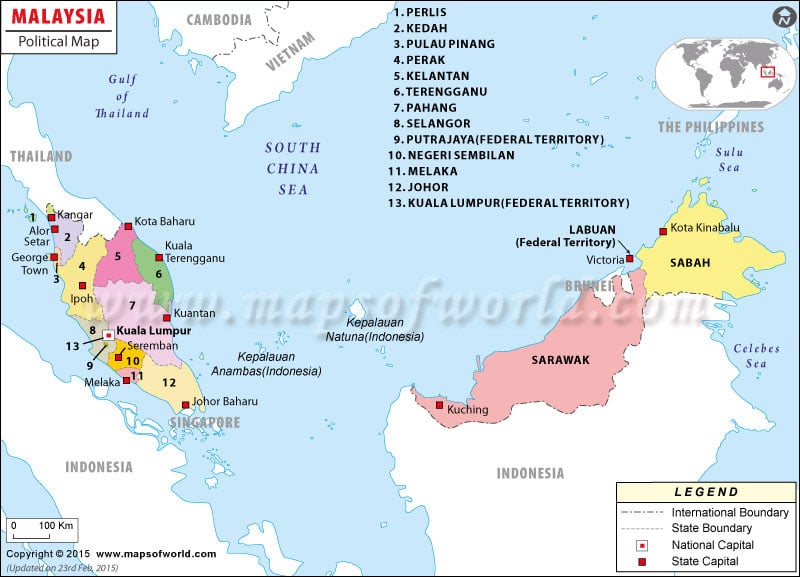
Malaysia is a Southeast Asian country, bordered by Thailand, Indonesia, and Brunei. Malaysia also shares maritime borders with Singapore, Vietnam, and the Philippines.
The country consists of two land areas, separated by the South China Sea. The capital of Malaysia is Kuala Lumpur, but Putrajaya is considered the administrative capital, as the seat of government.
Malaysia’s two regions together cover an area of 329,847 square kilometers (127,355 square miles). The regions are called Peninsular Malaysia, which is situated on the Malay Peninsula, bordering Thailand, and Malaysian Borneo, which is East Malaysia and is situated on the island of Borneo. Malaysian Borneo borders Indonesia and Brunei. The two regions differ in size, with Peninsular Malaysia covering around 40 percent of the total territory of Malaysia, and Malaysian Borneo making up the other 60 percent. However, about 80 percent of Malaysia’s population lives in Peninsular Malaysia.
Malaysia is divided into thirteen states and three territories. Peninsular Malaysia has eleven states and two federal territories. The states on Peninsular Malaysia are divided into four geographic regions. The states in the Northern Region include Perlis, Kedah, Penang, Perak. The East Coast Region states are Kelantan, Terengganu, and Pahang. The Southern Region contains the states of Negeri Sembilan, Malacca, and Johor. The Central Regions has the state of Selangor, as well as the two federal territories, Kuala Lumpur and Putrajaya. East Malaysia has the states of Sarawak and Sabah and the federal territory of Labuan.
| State | Population | Area(km.²) | Area(mi.²) | Capital |
|---|---|---|---|---|
| Johor | 2,584,997 | 18,985 | 7,330 | Johor Baharu |
| Kedah | 1,571,077 | 9,425 | 3,639 | Alor Star |
| Kelantan | 1,287,367 | 14,931 | 5,765 | Kota Baharu |
| Kuala Lumpur | 1,305,792 | 244 | 94 | Kuala Lumpur |
| Labuan | 70,871 | 98 | 38 | Victoria |
| Melaka | 605,239 | 1,650 | 637 | Melaka |
| Negeri Sembilan | 829,774 | 6,643 | 2,565 | Seremban |
| Pahang | 1,229,104 | 35,965 | 13,886 | Kuantan |
| Perak | 1,973,368 | 21,005 | 8,110 | Ipoh |
| Perlis | 198,288 | 795 | 307 | Kangar |
| Pulau Pinang | 1,231,209 | 1,033 | 399 | Georgetown |
| Putrajaya | 46 | 18 | Putrajaya | |
| Sabah | 2,468,246 | 73,711 | 28,460 | Kota Kinabalu |
| Sarawak | 2,009,893 | 124,449 | 48,050 | Kuching |
| Selangor | 3,952,817 | 7,910 | 3,054 | Shah Alam |
| Terengganu | 880,234 | 12,955 | 5,002 | Kuala Terengganu |
| 16 states | 22,198,276 | 329,845 | 127,354 |

 Wall Maps