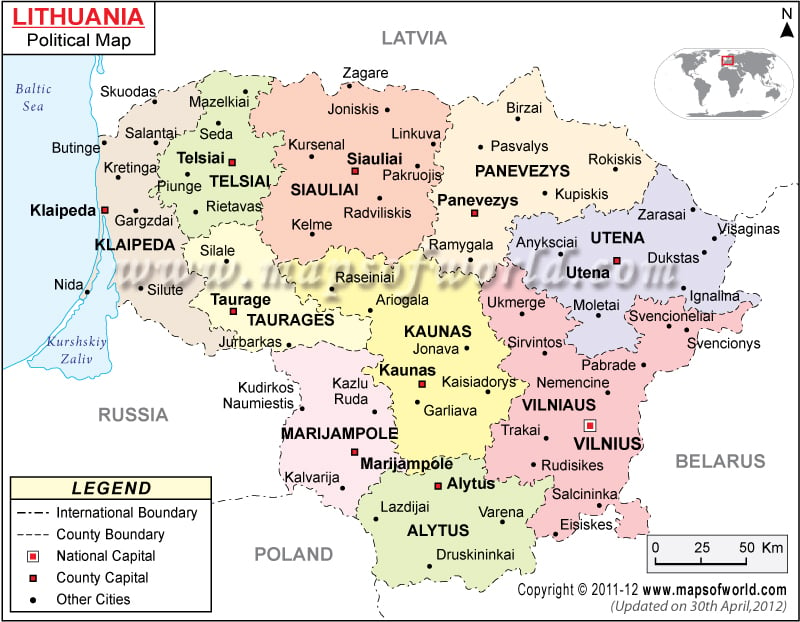
Lithuania is situated in Eastern Europe. The country shares its borders with Baltic Sea, Latvia and Russia as shown in the map of Lithuania. The geographical coordinates of the country are 56° North latitude and 24° East longitude. The Lithuania political map is very useful for cartographers, students and others who are interested to know about the country.
Geographical Coordinates of Lithuania
The geographical coordinates of Lithuania are 56° North latitude and 24° East longitude. The country occupies a total area of 65, 200 square kilometers. The coastline of the country stretches over an area of 90 kilometers and is marked with a blue line in the Lithuania map. The lowest point is Baltic Sea and the highest point is Jouzapines Kalnas situated at 293.6 meters above sea level. The climate of the country varies between maritime and continental.
National capital of Lithuania
Vilnius is the capital of Lithuania and is marked with a red dot within a square in the printable map of Lithuania. The latitudinal and longitudinal extent of the city is 54° 40′ 60” North and 25° 19′ East respectively. The Vilnius International Airport is the city’s main gateway and is served by many international and domestic airlines. The neighboring cities are Antakalnis, Nemezis, Guriai, Kirtimai, Viruliskiai, Kalvarijos and Pavilnys.
Lithuania Counties
There are 10 counties in Lithuania, which are marked with different colors on the printable map of Lithuania. These counties are mentioned below:
- Alytus County
- Kaunas County
- Klaipeda County
- Marijampole County
- Panevezys County
- Siauliai County
- Taurage County
- Telsiai County
- Utena County
- Vilnius County
The country is also divided into 60 municipalities and 500 elderates for better administration.
Locations in the Map
MAJOR COUNTY (APSKRITIS) LOCATIONS
Klaipedos, Telsiu, Taurages, Siauliu, Panevezio, Kauno, Utenos, Vilniaus, , Marijampoles, Alytaus.
NATIONAL CAPITAL VILNIUS.
MAJOR COUNTY (APSKRITIS) CAPITAL
Klaipeda, Telsiai, Taurage, Siauliai, Kaunas, Panevezys, Utena, Marijampole, Alytus, Vilniaus
OTHER MAJOR CITIES
Skuodas, Salantai, Butinge, Kretinga, Gargzdai, Silute, Mazelkiai, Seda, Piunge, Rietavas, Silale, Jurbarkas, Zagare, Kursenal, Linkuva, Joniskis, Radviliskis, Kelme, Raseiniai, Ariogala, Kedainiai, Jonava, Kaisiadorys, Garliava, Birzai, Pasvalys, Kupiskis, Ramygala, Rokiskis, Anyksciai, Zarasai, Visaginas, Dukstas, Ignalina, Moletai, Svencioneliai, Anyksciai, Ukmerge, Pabrade, Memencine, Vievis, Galiava, Kaisiadorys, Jonava, Ariogala, Kazly Ruda, Kybartai, Kalvarija, Lazdijai, Varena, Druskininkai, Eiseskes, Salcininka, Rudisikes, Trakai.
NEIGHBOUR COUNTRIES/ISLANDS Latvia, Russia, Belarus, Poland.
OCEANS, SEAS, RIVER, BAYS AND CANALS Baltic Sea, Kurshskiy Zaliv.
| Short Name | Full Name | Population | Area(km.²) | Area(mi.²) |
|---|---|---|---|---|
| Alytus | Alytaus Apskritis | 187,769 | 5,425 | 2,095 |
| Kaunas | Kauno Apskritis | 701,529 | 8,089 | 3,123 |
| Klaipeda | Klaipedos Apskritis | 385,768 | 5,209 | 2,011 |
| Marijampole | Marijampolės Apskritis | 188,634 | 4,463 | 1,723 |
| Panevezys | Panevezio Apskritis | 299,990 | 7,881 | 3,043 |
| Siauliai | Siauliu Apskritis | 370,096 | 8,540 | 3,297 |
| Taurage | Taurages Apskritis | 134,275 | 4,411 | 1,703 |
| Telsiai | Telsiu Apskritis | 179,885 | 4,350 | 1,680 |
| Utena | Utenos Apskritis | 185,962 | 7,201 | 2,780 |
| Vilnius | Vilniaus Apskritis | 850,064 | 9,731 | 3,757 |
| 10 counties | 3,483,972 | 65,300 | 25,212 |

