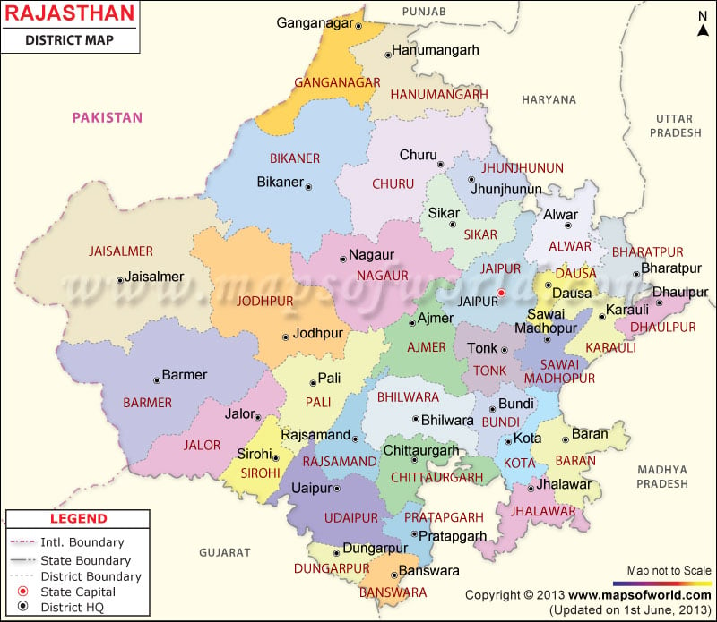
List of Rajasthan Districts |
|---|
| S.N. | District | Population (2011) | Area (sq km) |
|---|---|---|---|
| 1 | Ajmer | 2,584,913 | 8,481 |
| 2 | Alwar | 3,671,999 | 8,380 |
| 3 | Banswara | 1,798,194 | 5,037 |
| 4 | Baran | 1,223,921 | 6,955 |
| 5 | Barmer | 2,604,453 | 28,387 |
| 6 | Bharatpur | 2,549,121 | 5,066 |
| 7 | Bhilwara | 2,410,459 | 10,455 |
| 8 | Bikaner | 2,367,745 | 27,244 |
| 9 | Bundi | 1,113,725 | 5,550 |
| 10 | Chittorgarh | 1,544,392 | 10,856 |
| 11 | Churu | 2,041,172 | 16,830 |
| 12 | Dausa | 1,637,226 | 3,432 |
| 13 | Dholpur | 1,207,293 | 3,033 |
| 14 | Dungarpur | 1,388,906 | 3,770 |
| 15 | Hanumangarh | 1,779,650 | 12,645 |
| 16 | Jaipur | 6,663,971 | 14,068 |
| 17 | Jaisalmer | 672,008 | 38,401 |
| 18 | Jalor | 1,830,151 | 10,640 |
| 19 | Jhalawar | 1,411,327 | 6,219 |
| 20 | Jhunjhunu | 2,139,658 | 5,928 |
| 21 | Jodhpur | 3,685,681 | 22,850 |
| 22 | Karauli | 1,458,459 | 5,530 |
| 23 | Kota | 1,950,491 | 5,446 |
| 24 | Nagaur | 3,309,234 | 17,718 |
| 25 | Pali | 2,038,533 | 12,387 |
| 26 | Pratapgarh[1] | 868,231 | 4,117 |
| 27 | Rajsamand | 1,158,283 | 4,768 |
| 28 | Sawai Madhopur | 1,338,114 | 10,527 |
| 29 | Sikar | 2,677,737 | 7,732 |
| 30 | Sirohi | 1,037,185 | 5,136 |
| 31 | Sri Ganganagar | 1,969,520 | 7,984 |
| 32 | Tonk | 1,421,711 | 7,194 |
| 33 | Udaipur | 3,067,549 | 13,883 |

