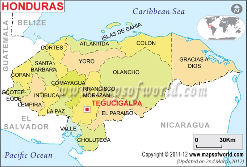
Honduras’ political map is helpful for all, who are interested to know about the country. The map features in detail the departmental divisions, the national capital, departmental capitals, and the important cities.
Honduras’ political map clearly shows the country’s capital, important cities, departmental boundaries, and capitals. The departmental boundaries are distinctly differentiated from each other by a violet line featuring the departmental capitals with green squares. The black dots on the Honduras map represent important cities, which are located across the country. A black bold line outlines the international boundary of the country. Web surfers can also see the neighboring countries on the online political map of Honduras.
Geographical Extent of Honduras
The latitudinal and longitudinal extents of Honduras are 15° north and 86° 30′ West respectively. The country stands in Central America, bordering Nicaragua, El Salvador, and Guatemala as shown on the map of Honduras. The Caribbean Sea lies in the northern part of the country. Honduras is spread over an area of 112, 090 square kilometers. The total area is divided between the land area covering about 111,890 square kilometers and water bodies covering about 200 square kilometers. The coastline of Honduras is marked with a bold black line stretching over an area of 820 kilometers.
The Caribbean Sea is the lowest point and the highest point is Cerro las Minas situated 2,870 meters above sea level.
Departmental Boundaries
|
|
|
|
Some of the departmental capitals as marked with green squares on the printable map of Honduras. These capitals are la Ceiba, San Pedro Sula, Yoro, Juticalpa, La, La Paz, La Esperanza, Neuva Dcotepeque, Yuscaran, Nacaome, Choluteca and Gracias.
Important cities of Honduras
The important cities are marked with black dots on the Honduras political map. Some of the cities are Cedros, Auastila, Leirnus, Catacamas, Sabana Grande, Nueva Arcadia, Salama, Pueble Viejo, Balfate, San Esteban and El Progresso.
Capital of Honduras
The capital city of Honduras is Tegucigalpa, situated at an altitude of 980 meters. Web surfers can quickly point out the capital by the red star used to mark the capital city. The latitudinal and longitudinal extent of the town is 14° 5′ 60” North and 87° 13′ West respectively. Some of the neighboring cities are:
|
|
|
|
|
|
|
|
|
|
The city also towers over some of the airports in Honduras. They are Toncontin Inetrnational, Tamarindo, Los Comandos and Coronel Enrique Soto Cano.
Locations in the Map
MAJOR DEPARTMENTAL LOCATION
Copan, Dcotepeque, Lempira, Santa Barbara, Intibuca, Comayagua, Yoro, La Paz, Colon, Olancho, Francisco Morazan, El Paraiso, Valle, Choluteca, Gracias A Dios.
NATIONAL CAPITAL
MAJOR DEPARTMENTAL CAPITAL
Santa Rosa De Copan, Nuiva Dcotepeque, Gracias, Santa Barbara, San Pedro Sula, La Esperanza, Yoro, La Ceiba, Comayagua, La Paz, Tegucigalpa, Nacaome, Choliuteca, Yuscaran, Juticalpa, Trujillo, Puerto Lempira.
OTHER MAJOR CITIES
Nueva Arcadia, El Progresso, Santa Rita, San Lorenzo, Olanchino, Cedros, Sabana Grande, Salama, Pueble Viejo, San Esteban, Catacamas, Tocoa, Balfate, Auastila, Leimus.
NEIGHBOUR COUNTRIES/ISLANDS Guatemala, El Salvador, Nicaragua, Belize, Costa Rica.
OCEANS, SEAS, RIVER, BAYS, AND CANALS Caribbean Sea, Pacific Ocean.
| Department | Population | Area(km.²) | Area(mi.²) | Capital |
|---|---|---|---|---|
| Atlantida | 344,099 | 4,251 | 1,641 | La Ceiba |
| Choluteca | 390,805 | 4,211 | 1,626 | Choluteca |
| Colon | 246,708 | 8,875 | 3,427 | Trujillo |
| Comayagua | 352,881 | 5,196 | 2,006 | Comayagua |
| Copan | 288,766 | 3,203 | 1,237 | Santa Rosa (de Copan) |
| Cortes | 1,202,510 | 3,954 | 1,527 | San Pedro Sula |
| El Paraiso | 350,054 | 7,218 | 2,787 | Yuscaran |
| Francisco Morazan | 1,180,676 | 7,946 | 3,068 | Tegucigalpa |
| Gracias a Dios | 67,384 | 16,630 | 6,421 | Puerto Lempira |
| Intibuca | 179,862 | 3,072 | 1,186 | La Esperanza |
| Islas de la Bahia | 38,073 | 261 | 101 | Roatan |
| La Paz | 156,560 | 2,331 | 900 | La Paz |
| Lempira | 250,067 | 4,290 | 1,656 | Gracias |
| Ocotepeque | 108,029 | 1,680 | 649 | Nueva Ocotepeque |
| Olancho | 419,561 | 24,351 | 9,402 | Juticalpa |
| Santa Barbara | 342,054 | 5,115 | 1,975 | Santa Barbara |
| Valle | 151,841 | 1,565 | 604 | Nacaome |
| Yoro | 465,414 | 7,939 | 3,065 | Yoro |
| 18 departments | 6,535,344 | 112,088 | 43,278 |

 Wall Maps