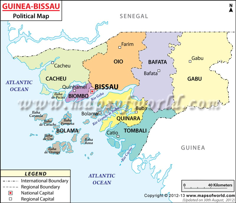
The political map of Guinea Bissau shows various features of the country such as international and internal boundaries, provinces, and major cities. The country has a coastline of 350 kilometers. The population of the country is 19.7 lakhs (2020)
Guinea Bissau Features
Guinea Bissau or the Republic of Guinea Bissau is a West African country. The country attained independence in the year 1974 from Portugal. The geographic coordinates of Guinea Bissau are 12° North latitude and 15° West longitude. The total area of the country is 36, 125 square kilometers. Timber, fish, bauxite, phosphates, and limestone are some of the natural resources of the country. In the political map of Guinea Bissau, the national capital, provinces and their capitals, major cities, and internal and international boundaries are indicated distinctively.
Guinea Bissau Provinces
For administrative purposes, Guinea Bissau has been divided into nine provinces or regions. The provinces of Guinea Bissau have been indicated on the map by using different colors. The Guinea Bissau provinces given in printable map of Guinea Bissau Map are Biombo, Bafata, Bolama, Bissau, Cacheu, Oio, Gabu, Tombali, Quinara.
Guinea Bissau Capital
Bissau is the capital of the Republic of Guinea Bissau. The geographic coordinates of Bissau are 11° 50′ 60″ North latitude and 15° 34′ 60″ West longitude. The capital of Guinea Bissau is marked in the political printable map of Guinea Bissau by a red square that is bounded by a black border. Bissau is the major port of the country. The military center of the country is also in Bissau. The city has a lot of attractions like the Pidjiguiti Memorial, and Guinea Bissau national Arts Institute. Some of the cities that lie in close proximity to Bissau are:
|
|
|
|
|
|
|
|
|
|
|
|
|
|
|
|
|
|
|
|
|
|
The airports that are in close proximity to the capital city are:
Check: /international-airports/africa/guinea-bissau.html
|
|
|
|
Guinea Bissau provinces Capitals
The capitals of the provinces of the country Guinea Bissau have been indicated on the map by using white boxes. The capitals of the provinces given in the political Guinea Bissau map are:
|
|
|
|
|
|
|
|
Cities of Guinea Bissau
Some of the major cities of Guinea Bissau have been indicated on the political map by using black dots. Some of the important cities that have been indicated in the country are:
Check: /guinea-bissau/cities-map.html
|
|
|
|
|
|
|
|
|
Boundaries of Guinea Bissau
The international boundaries of Guinea Bissau have been marked on the political map of the country by using black lines of a specific pattern. The countries that are neighbors to Guinea Bissau are Guinea to the eastern and southern side and Senegal to the north. The Atlantic Ocean surrounds the country on the western side.
| Region | Population | Area(km.²) | Area(mi.²) | Capital |
|---|---|---|---|---|
| Bafata | 210,007 | 5,981 | 2,310 | Bafata |
| Biombo | 97,120 | 839 | 324 | Quinhamel |
| Bissau | 387,909 | 77 | 30 | Bissau |
| Bolama | 34,563 | 2,624 | 1,014 | Bolama |
| Cacheu | 192,508 | 5,174 | 1,998 | Cacheu |
| Gabu | 215,530 | 9,150 | 3,534 | Gabu |
| Oio | 224,644 | 5,404 | 2,087 | Farim |
| Quinara | 63,610 | 3,138 | 1,212 | Buba |
| Tombali | 94,939 | 3,736 | 1,443 | Catio |
| 9 divisions | 1,520,830 | 36,123 | 13,952 |

