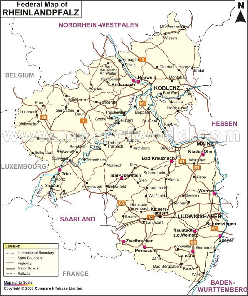
Rhineland-Palatinate
Located in the western part of Germany, Rhineland-Palatinate is one of the 16 states that form the Federal Republic of Germany. Rhineland-Palatinate is spread over an area of 7,663 square miles and is home to some four million inhabitants. Rhineland-Palatinate shares its borders with four other German states – North Rhine-Westphalia, Hesse, Baden-Württemberg, and Saarland – and three nations – Belgium, France and Luxemburg.
The Rhineland-Palatinate state came into existence in 1946. The northern part of the French Occupation Zone, southern parts of the Prussian Rhine Province, some areas of the Prussian Province of Nassau, and those of Hesse-Darmstadt were merged into a single entity to form what we know today as the state of Rhineland-Palatinate. The state today comprises 36 districts of which 24 are rural while 12 are urban.
Rhineland-Palatinate offers many attractions to tourists. You can plan a trip to Cochem, which is a picturesque town located on the Moselle River. One of the sights that define the town is its jaw-dropping vineyards.
Standing amidst lush-green forests, Stolzenfels Castle was initially built by the Prince-Bishop of Trier. However, the Nine Year’s War saw the castle being completely destroyed by the French in 1689. The city of Koblenz presented the ruins of the castle to Frederick William IV of Prussia in 1823. He completely rebuilt the castle and began using it as his summer residence.
Zell will definitely appeal to wine lovers as it holds the distinction of being the second largest wine growing center located in Germany’s Mosel wine region.
Some other attractions that one can visit in Rhineland-Palatinate include St. Stephan’s Church, St. Peter’s Cathedral, Technik Museum Speyer, Mittelalterlicher Marktplatz, and many others. In addition to this there are many walking trails, historical places, wine making regions and modern cities that need to be explored.
International travelers can get down at the Hahn Airport which is located in the state. It is well-connected to other parts of the country as well as major cities around the world. However, if you plan to visit Rhineland-Palatinate by train, then you can easily get one from Munich, Stuttgart, Cologne and Frankfurt.
Districts in Rheinland-Pfalz |
|---|
| District | Abbreviation | Capital | Population | Area(km.²) |
|---|---|---|---|---|
| Ahrweiler | AR | Bad Neuenahr-Ahrweiler | 125,885 | 787 |
| Altenkirchen (Westerwald) | AT | Altenkirchen (Westerwald) | 130,570 | 642 |
| Alzey-Worms | AW | Alzey | 125,113 | 588 |
| Bad Dürkheim | BD | Bad Dürkheim | 131,085 | 595 |
| Bad Kreuznach | BK | Bad Kreuznach | 155,599 | 864 |
| Bernkastel-Wittlich | BW | Wittlich | 112,320 | 1,178 |
| Birkenfeld | BR | Birkenfeld | 82,778 | 779 |
| Cochem-Zell | CZ | Cochem | 64,187 | 719 |
| Donnersbergkreis | DN | Kirchheimbolanden | 76,030 | 645 |
| Eifelkreis Bitburg-Prüm | EB | Bitburg | 95,774 | 1,626 |
| Frankenthal (Pfalz) | FA | Frankenthal (Pfalz) | 46,415 | 44 |
| Germersheim | GR | Germersheim | 123,913 | 463 |
| Kaiserslautern | KL | Kaiserslautern | 105,283 | 640 |
| Kaiserslautern | KS | Kaiserslautern | 96,341 | 140 |
| Koblenz | KO | Koblenz | 107,825 | 105 |
| Kusel | KU | Kusel | 72,783 | 573 |
| Landau in der Pfalz | LP | Landau in der Pfalz | 43,361 | 83 |
| Ludwigshafen am Rhein | LR | Ludwigshafen am Rhein | 157,584 | 78 |
| Mainz | MI | Mainz | 200,344 | 98 |
| Mainz-Bingen | MB | Ingelheim am Rhein | 200,672 | 606 |
| Mayen-Koblenz | MK | Koblenz | 210,308 | 817 |
| Neustadt an der Weinstraße | NW | Neustadt an der Weinstraße | 52,164 | 117 |
| Neuwied | NU | Neuwied | 180,672 | 627 |
| Pirmasens | PR | Pirmasens | 40,887 | 61 |
| Rhein-Hunsrück-Kreis | RH | Simmern/Hunsrück | 102,322 | 963 |
| Rhein-Lahn-Kreis | RN | Bad Ems | 123,203 | 782 |
| Rhein-Pfalz-Kreis | RZ | Ludwigshafen am Rhein | 146,868 | 305 |
| Speyer | SE | Speyer | 49,540 | 43 |
| Südliche Weinstraße | SW | Landau in der Pfalz | 108,244 | 640 |
| Südwestpfalz | SD | Pirmasens | 98,426 | 954 |
| Trier | TI | Trier | 105,671 | 117 |
| Trier-Saarburg | TS | Trier | 142,228 | 1,091 |
| Vulkaneifel | VL | Daun | 61,947 | 911 |
| Westerwaldkreis | WS | Montabaur | 200,059 | 989 |
| Worms | WR | Worms | 79,207 | 109 |
| Zweibrücken | ZE | Zweibrücken | 34,200 | 71 |

