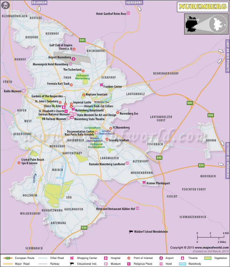
Nuremberg Attractions |
|---|
| Nuremberg Zoo Am Tiergarten Nuremberg Germany |
| Germanisches Nationalmuseum Kartausergasse Nuremberg Germany |
| Kaiserburg Burg Nuremberg Germany |
| Frankenstadion Nuremberg Germany |
| Cosmos Bowling Arena Nurnberg Matthaus-Herrmann-Platz Nuremberg Germany |
| St. Lorenz Lorenzer Platz Nuremberg Germany |
| Albrecht-Durer-Haus Albrecht-Durer-Straße Nuremberg Germany |
| Documentation Center Nazi Party Rally Grounds Bayernstraße Nuremberg Germany |
| Kath. Pfarramt Frauenkirche (Zu Unserer Lieben Frau) Winklerstraße Nuremberg Germany |
| St. Sebald Winklerstraße Nuremberg Germany |
| St. Rochus Cemetery Beim Rochuskirchhof 17/ Nuremberg Germany |
| Academy of Fine Arts Bingstraße Nuremberg Germany |
| Way of Human Rights Kartausergasse Nuremberg Germany |
| Fleischbrucke Nuremberg Germany |
Climate Data for Nuremberg, Germany for 1981–2010, Record Temperatures for 1955-2013 |
| Month | Jan | Feb | Mar | Apr | May | Jun |
|---|---|---|---|---|---|---|
| Record high °C (°F) | 15.0 (59) | 19.3 (66.7) | 23.7 (74.7) | 31.0 (87.8) | 32.2 (90) | 35.1 (95.2) |
| Average high °C (°F) | 2.5 (36.5) | 4.4 (39.9) | 9.2 (48.6) | 16.4 (61.5) | 21.4 (70.5) | 23.8 (74.8) |
| Daily mean °C (°F) | 0.0 (32) | 0.8 (33.4) | 4.7 (40.5) | 9.0 (48.2) | 14.0 (57.2) | 16.9 (62.4) |
| Average low °C (°F) | −3.1 (26.4) | −2.9 (26.8) | 0.4 (32.7) | 3.3 (37.9) | 8.0 (46.4) | 12.1 (53.8) |
| Record low °C (°F) | −25.4 (−13.7) | −30.2 (−22.4) | −18.3 (−0.9) | −9.2 (15.4) | −4.3 (24.3) | 0.0 (32) |
| Average precipitation mm (inches) | 41.7 (1.642) | 36.6 (1.441) | 47.0 (1.85) | 39.8 (1.567) | 60.8 (2.394) | 66.1 (2.602) |
| Mean monthly sunshine hours | 58.2 | 87.2 | 116.8 | 175 | 216 | 217.9 |
| Month | Jul | Aug | Sep | Oct | Nov | Dec | Year |
|---|---|---|---|---|---|---|---|
| Record high °C (°F) | 38.6 (101.5) | 37.6 (99.7) | 32.3 (90.1) | 27.7 (81.9) | 20.4 (68.7) | 15.1 (59.2) | 38.6 (101.5) |
| Average high °C (°F) | 26.6 (79.9) | 26.2 (79.2) | 19.4 (66.9) | 13.9 (57) | 7.2 (45) | 3.5 (38.3) | 13.8 (56.8) |
| Daily mean °C (°F) | 19.1 (66.4) | 18.4 (65.1) | 14.0 (57.2) | 9.3 (48.7) | 4.2 (39.6) | 1.0 (33.8) | 9.3 (48.7) |
| Average low °C (°F) | 13.3 (55.9) | 12.7 (54.9) | 9.0 (48.2) | 5.2 (41.4) | 1.2 (34.2) | −1.8 (28.8) | 4.7 (40.5) |
| Record low °C (°F) | 3.1 (37.6) | 0.6 (33.1) | −2.7 (27.1) | −7.3 (18.9) | −12.7 (9.1) | −23.0 (−9.4) | −30.2 (−22.4) |
| Average precipitation mm (inches) | 80.4 (3.165) | 63.5 (2.5) | 49.6 (1.953) | 52.6 (2.071) | 47.4 (1.866) | 51.4 (2.024) | 636.8 (25.071) |
| Mean monthly sunshine hours | 234.7 | 219.9 | 161.2 | 114.4 | 57.2 | 43.2 | 1701.6 |

