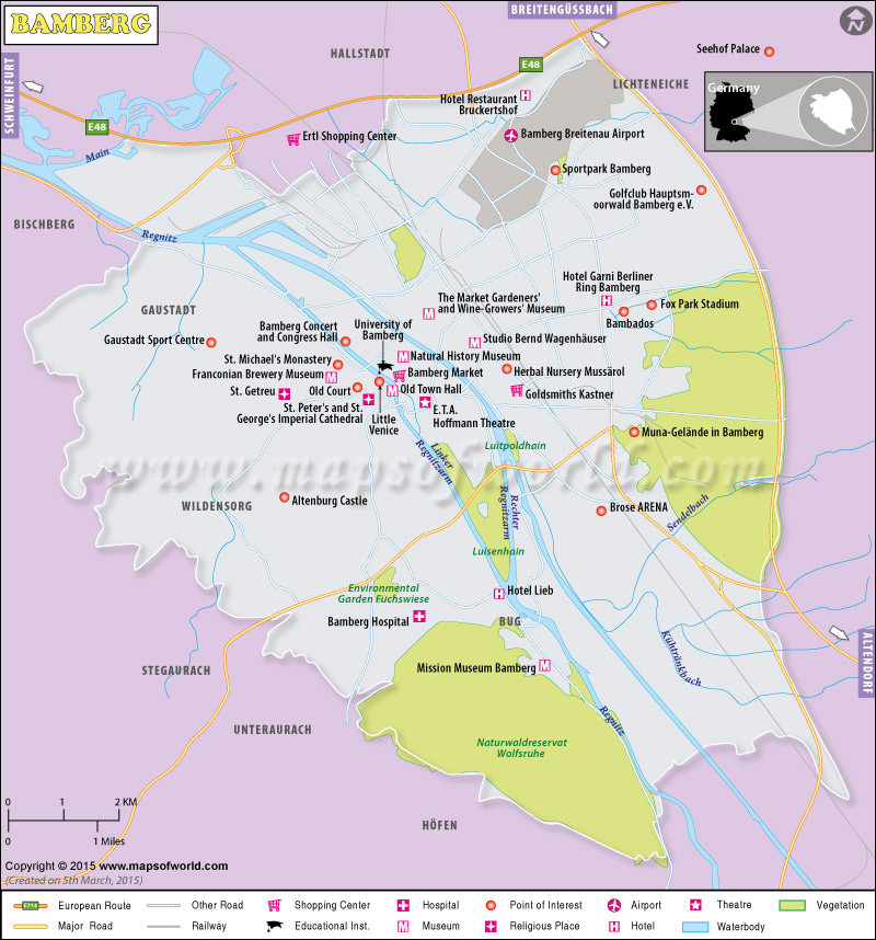
The topography of Bamberg is shaped by its adjacent River Regnitz and the upper lands of Steigerwald. The town is vertically separated into the Regnitz plain, a large and several small islands joined by two arms of the Regnitz (Inselstadt), and the town of Hill Town or Bergstedt. Due to its geographical similarity with Rome, Bamberg is often called Franconian Rome or the Italian Bamberg. Like the former, Bamberg also extends over seven hills, each capped by a church. The population is around 7000, out of which 4100 are American army men and their dependents.
The main attraction of Bamberg Germany :
- Bamberg Cathedrals made in the 13th century, is a medieval looked national asset of Germany (German: Deutschlandkarte), that is also included in the World Heritage.
- Bamberg Altes Rathaus or Old Town Hall (1386), was built in the middle of River Regnitz and opened from both sides of two bridges Klein-Venedig
- The adjacent colony of Klein-Venedig or “Little Venice” is composed of picturesque fishermen’s houses.
- A magnificent marble tombed cathedral of Roman architecture with four imposing towers, founded in 1004 by the emperor Henry II.
- Neue Residenz or New Palace in English is a 17th-century creation.
- Rosengarten (Rose Garden) with excellent views of the city, Bamberg.
- Castle Altenburg crowns the highest point of Bamberg.
- Churches of Jakobskirche, St Martinskirche; the Marienkirche or Obere Pfarrkirche the Michaelskirche, the Michaelsberg, the Burgerspital.
- Rathaus or City Hall
- Old Palace or Alte Hofhaltung
- Maximilian fountain of the 19th century with statues of Maximilian I of Bavaria, emperor Henry II and his wife, Conrad III, and St Otto and bishop of Bamberg.
Bamberg, the home of many breweries and vineyards, is a commercially rich land. The Klosterbräu brewery is famous for its smoked beer or Rauchbier. Other famous ones include, Schlenkerla “Aecht Schlenkerla Rauchbier”, Brauerei Fässla, Brauerei Greifenklau, Brauerei Heller-Trum (“Schlenkerla”), Brauerei Kaiserdom, Keesmann Bräu, Klosterbräu, Mahrs Bräu, Maisel Bräu and Brauerei Spezial and a microbrewery of Ambräusianum.
Climate Data for Bamberg (1981–2010) |
| Month | Jan | Feb | Mar | Apr | May | Jun |
|---|---|---|---|---|---|---|
| Average high °C (°F) | 2.9 (37.2) | 4.7 (40.5) | 9.5 (49.1) | 14.8 (58.6) | 19.7 (67.5) | 22.5 (72.5) |
| Average low °C (°F) | −3.2 (26.2) | −3.0 (26.6) | 0.2 (32.4) | 3.1 (37.6) | 7.6 (45.7) | 10.7 (51.3) |
| Average rainfall mm (inches) | 47.1 (1.854) | 39.0 (1.535) | 49.4 (1.945) | 41.5 (1.634) | 64.4 (2.535) | 61.4 (2.417) |
| Mean monthly sunshine hours | 51.2 | 81.3 | 112.3 | 170.4 | 208.8 | 211.2 |
| Month | Aug | Sep | Oct | Nov | Dec | Year |
|---|---|---|---|---|---|---|
| Average high °C (°F) | 24.5 (76.1) | 19.8 (67.6) | 14.1 (57.4) | 7.3 (45.1) | 3.6 (38.5) | 14.03 (57.24) |
| Average low °C (°F) | 12.2 (54) | 8.6 (47.5) | 5.0 (41) | 1.2 (34.2) | −1.8 (28.8) | 4.44 (40.02) |
| Average rainfall mm (inches) | 55.3 (2.177) | 56.8 (2.236) | 51.1 (2.012) | 51.9 (2.043) | 55.0 (2.165) | 650.9 (25.624) |
| Mean monthly sunshine hours | 213.3 | 155.6 | 105 | 48.8 | 39.6 | 1624 |

