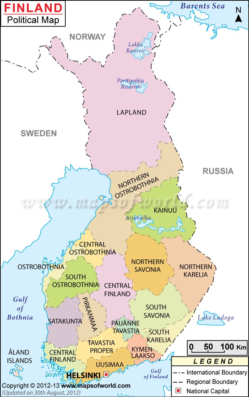
Finland is located between Russia and Sweden. It covers an area of 338,145 sq km and the geographical coordinates of Finland are 62.43° North and 24.72° East latitude and longitude respectively.
It borders the Gulf of Bothnia, the Baltic Sea, and the Gulf of Finland. The map of Finland shows these border areas in blue color.
Border countries of Finland
The countries that surround Finland are:
Finland has got a coastline measuring 1,250 km. The Baltic Sea is the lowest point and Haltiatunturi is the highest point in Finland.
States of Finland
The various states of Finland along with their capital city are given below:
- Lappi: Its capital is Rovaniemi
- Oulu: Its capital is Oulu
- Vaasa
- Keskisuomi: Its capital is Jyvaskyla
- Kuopio: Its capital is Kuopio.
- Pohjois Karjala: Its capital is Joensuu
- Turku Ja Pori: Its capital is Turku
- Hame: Its capital is Hameenlinga
- Mikkeli: Its capital is Mikkeli
- Kouvola: Its capital is Kymi
- Uusimaa: Its capital is Helsinki
These states of Finland are highlighted with jet black color on the Finland Political Map. On the other hand, the capital cities of the various states of Finland have been shown by a square box on the Map of Finland.
Cities of Finland
There are a large number of cities in Finland. These are Lvalo, Munnio, Kolari, Kemijarvi, Kelloselka, Tormio, Kemi, Taivalkoski, Raahe, Kajaani, Ylivieska, Seinajoki, Jisalmi, Lieksa, Homantsi, Jamsa, Aanekoski, Parkano, Virrat, Savoolina, Pieksamaki, Tampere, Lahti, Forssa, Pori, Salo, Hanko, Porvoo, Hyvinkaa, Valimaa, Lappeanranta, Matra and Kokkola. They can be easily located on the Political Map of Finland by the black dots representing them.
Black dotted lines on the Physical Map of Finland stand for the national and international boundaries.
Capital of Finland
Helsinki is the capital of Finland and lies on the coordinates of 60° 10′ North and 24° 56′ East latitude and longitude respectively. It is situated at an altitude of 25 meters above sea level. Some of the nearby places are:
- Framre Tolo
- Taka-Toolo
- Kamppi
- Kluuvi
- Pasila
- Toolo
The nearest airports include Helsinki Malmi, Helsinki Vantaa, Nummela and Hyvinkaa. Helsinki can be identified in the southern part of the Map of Finland marked by a red square.
| Region | Population: 2008-12-31 estimate (using 2009 regional division) | Area(km.²) | Area(mi.²) | Prov | Capital |
|---|---|---|---|---|---|
| aland | 27,456 | 1,553 | 599 | Mariehamn | |
| Central Finland | 271,747 | 16,707 | 6,450 | LS | Jyvaskyla |
| Central Ostrobothnia | 71,029 | 5,273 | 2,036 | LS | Kokkola |
| Kainuu | 83,160 | 21,504 | 8,303 | OL | Kajaani |
| Kanta-Hame | 173,041 | 5,200 | 2,008 | ES | Hameenlinna |
| Kymenlaakso | 182,754 | 5,112 | 1,974 | ES | Kotka |
| Lapland | 183,963 | 92,664 | 35,778 | LL | Rovaniemi |
| North Karelia | 166,129 | 17,763 | 6,858 | IS | Joensuu |
| North Ostrobothnia | 386,144 | 35,236 | 13,605 | OL | Oulu |
| North Savo | 248,423 | 16,771 | 6,475 | IS | Kuopio |
| Ostrobothnia | 175,985 | 7,749 | 2,992 | LS | Vaasa |
| Paijat-Hame | 200,847 | 5,127 | 1,979 | ES | Lahti |
| Satakunta | 227,652 | 7,957 | 3,072 | LS | Pori |
| South Karelia | 134,448 | 5,613 | 2,167 | ES | Lapeenranta |
| South Ostrobothnia | 193,511 | 13,444 | 5,191 | LS | Seinajoki |
| South Savo | 156,632 | 13,986 | 5,400 | IS | Mikkeli |
| Southwest Finland | 461,177 | 10,663 | 4,117 | LS | Turku |
| Tampere Region | 480,705 | 12,447 | 4,806 | LS | Tampere |
| Uusimaa | 1,501,511 | 9,131 | 3,526 | ES | Helsinki |
| Total exc. aland | 5,298,858 | 302,346 | 116,737 |

