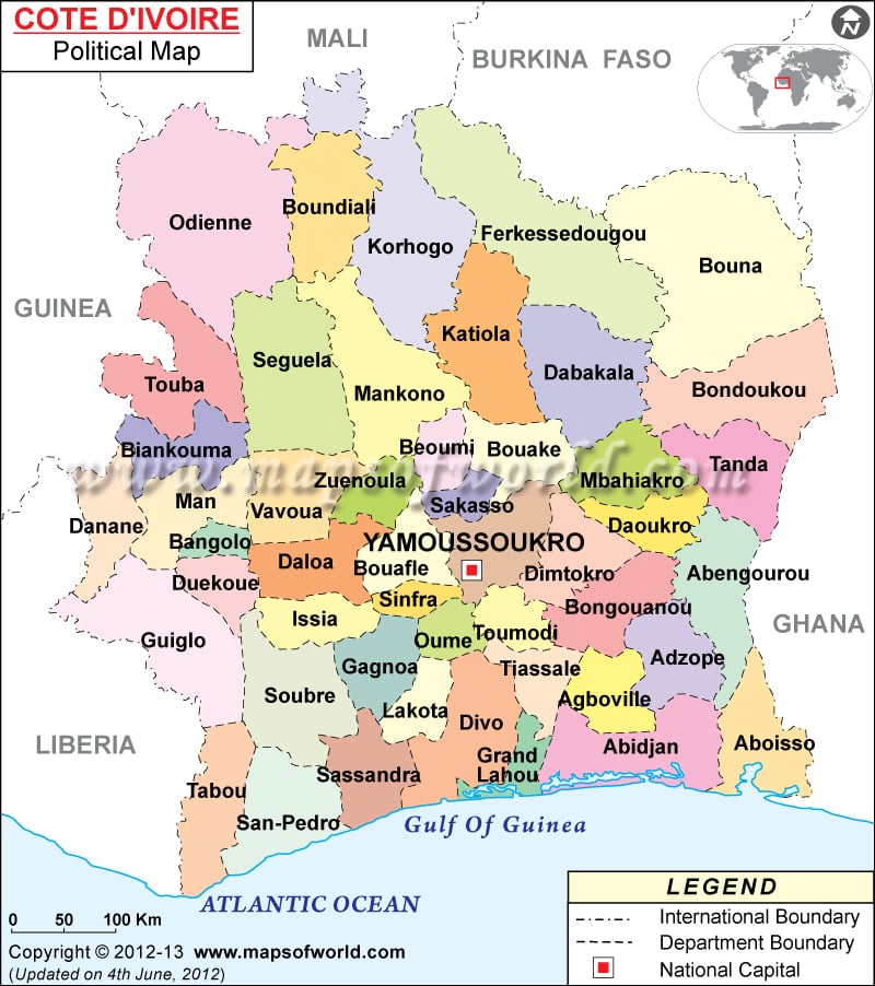
Cote D’ Ivoire Political Map shows the international boundary of the country with Broken lines with dots while the provincial boundaries are marked with broken lines. The geographical coordinates of the country are 8° North latitude and 5° West longitude. The capital of Cote D’Ivoire is Yamoussoukro situated at an altitude of 217 meters above sea level.
The Cote D’ Ivoire Political Map clearly demarcates the international boundary of the country, provincial boundaries with their capitals, national capital, and other important cities. The Cote D’Ivoire map also shows the bordering countries of Cote D’Ivoire. The neighboring countries are Mali, Burkina Faso, Ghana, Guinea, and Liberia. The water of the Gulf of Guinea washes the shores of the Cote D’Ivoire in the southern part.
Geography and Location
The geographical coordinates of the country are 8° North latitude and 5° West longitude. The total area of Cote D’Ivoire is 322,460 square kilometers, of which the land area is 318,000 square kilometers. About 4,460 kilometers are covered by water bodies. Mont Nimba is the highest point of the country situated at a height of 1,752 meters above sea level. The Gulf of Guinea is considered to be the lowest point in the country. The country’s coastline extends up to 515 kilometers.
Capital of Cote D’Ivoire
The capital of Cote D’Ivoire is Yamoussoukro. The geographical coordinates of the city are 6° 49′ North and 5° 16′ 60” West respectively. The city is situated at an altitude of 217 meters above sea level. The capital city is spread over an area of 3,500 square kilometers. The nearby cities and towns are Bonzi, Abouassikro, Nzuessi, Nanan and Akpessekro. Yamoussoukro and Bouake are the two airports located in the region. The present governor of the city is N’Dri Koffi Apollinaire.
Provincial Capitals
The provinces of the country are individually colored in order to differentiate them from each other. The provincial capitals, which are pointed on the map of Cote D’Ivoire, are:
| Odienne | Boundiali | Korhogo | Ferkesseedougou |
| Bouna | Touba | Seguela | Mankono |
| Katiola | Dabakala | Bondoukou | Biankouma |
| Danane | Man | Vavoua | Zuenoula |
| Beoumi | Bouaka | Tanda | Mbahiakro |
| Bangolo | Sakasso | Daoukro | Bouafle |
| Duekou | Dimtokro | Abengourou | Yamoussoukro |
| Daloa | Issia | Guiglo | Oume |
| Toumodi | Sinfra | Soubre | Gagnoa |
| Lakota | Divo | Tiassale | Agboville |
| Aboisso | Divo | Tabou | San- Pedro |
| Sassandro | Grand Lahou | Abidjan | Aboisso |
| Agboville | Adzope | Bongourou | Abengourou |
Provinces of Cote Dlvorie |
|---|
| Region | Capital | Population – 1998 Census | Area(km.²) |
|---|---|---|---|
| Agneby | Agboville | 525,211 | 9,234 |
| Bafing | Touba | 139,251 | 8,922 |
| Bas-Sassandra | San-Pedro | 1,395,251 | 26,440 |
| Denguele | Odienne | 222,446 | 20,997 |
| Dix-Huit Montagnes | Man | 936,510 | 16,782 |
| Fromager | Gagnoa | 542,992 | 6,903 |
| Haut-Sassandra | Daloa | 1,071,977 | 15,242 |
| Lacs | Yamoussoukro | 476,235 | 8,875 |
| Lagunes | Abidjan | 3,733,413 | 13,323 |
| Marahoue | Bouafle | 554,807 | 8,698 |
| Moyen-Cavally | Guiglo | 508,733 | 14,268 |
| Moyen-Comoe | Abengourou | 394,761 | 6,921 |
| N’zi-Comoe | Dimbokro | 633,927 | 19,242 |
| Savanes | Korhogo | 929,673 | 40,210 |
| Sud-Bandama | Divo | 682,021 | 10,677 |
| Sud-Comoe | Aboisso | 459,487 | 7,252 |
| Vallee du Bandama | Bouake | 1,080,509 | 28,518 |
| Worodougou | Seguela | 378,463 | 22,166 |
| Zanzan | Bondoukou | 701,005 | 38,251 |

