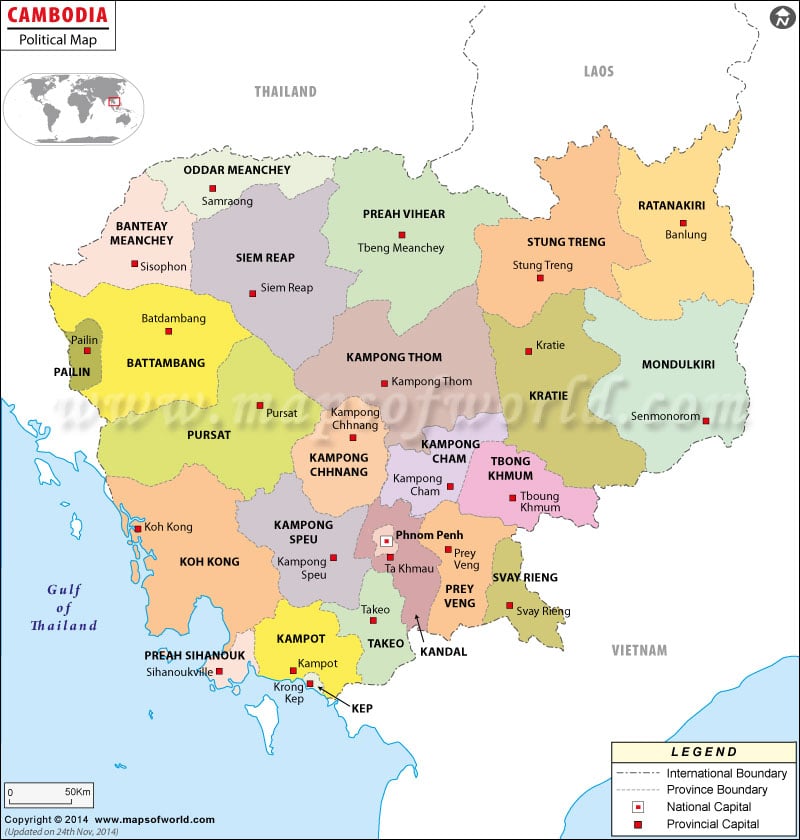
Cambodia is a southeastern Asian country and the capital of the country is Phnum Penh. The residents of the country are known as “Khmer” or “Cambodian”. The country is characterized by two separate seasons. In the Cambodia political map, various features of the country have been highlighted.
Cambodia is located at southeastern Asia. The total area of Cambodia is 181,040 square kilometers. The population of Cambodia as per the estimate taken in 2007 July was 13,995,904. The geographic coordinates of Cambodia are 13° North latitude and 105° East longitude. In the political map of Cambodia, details like provinces and their capitals, international boundaries and the neighboring countries, provincial capital all have been provided using specific symbols.
Cambodia Capital
The capital of Cambodia is Phnum Penh. The geographic coordinates of Phnum Penh are 11°33′ N latitude and 104°55′ E longitude. Phnum Penh is located at 52 feet above sea level. The nearby airports of the capital city are Kampong Chhnang and Phnom Penh Intl. Some of the cities that lie in close proximity to Phnum Penh are:
| Stoeng Mean Chey | Phumi Kaoh Norea | Toek L’ak |
| Khum Dangkao | Chrouy Changvar | Khum Chbar Ampou |
| Phumi Prey Sambuor |
Cambodia States
The Cambodia states have been indicated in the printable map of Cambodia by different colors. The state boundaries are also indicated in the map using a definite pattern of black lines. The different Cambodia states that are highlighted in the political Cambodia map are:
| Preah Seihanu | Kampot | Keb |
| Takev | Kaoh Kaoh | Kampong Spoe |
| Phnom Penh | Kandal | Prey Veng |
| Svayrieng | Pouthisat | Kampong Chhnang |
| Kampong Cham | Batdambang | Kampong Thum |
| Kracheh | Mondol Kiri | Banteay Mean Cheay |
| Siem Reab | Preah Vihear | Stoeng Treng |
| Rotanah Kiri | Otsar Mean Cheay |
Cambodia State Capitals
The capitals of the states of Cambodia are highlighted in the map of Cambodia by using white boxes. Some of the capitals of the states of Cambodia that are indicated in the map are:
| Keb | Preah Seihanu | Kampong Spoe |
| Takev | Ta Khmfau | Svay Rieng |
| Prey Veng | Kampong Cham | Sisophon |
| Batdambang | Pouthisat | Lumphat |
| Stoeng Treng | Siemreab | Phnum Tbeng Meanchey |
Cambodia major cities
The important cities of Cambodia have been indicated in the political map of Cambodia by using black dots. Some of the cities of Cambodia, which are printed in the map, are:
| Phomi Samraong | Choam Khsant | Siempang |
| Virochey | Bong Long | Moung Roessei |
| Sambor | Sandan | Sre Ambel |
| Kampong Trabek |
Provinces of Cambodia |
|---|
| Province | Capital | Pop-2008 | Area(km.²) | Area(mi.²) |
|---|---|---|---|---|
| Bântéay Méanchey | Sisophon | 677,872 | 6,679 | 2,579 |
| Bătdâmbâng | Batdâmbâng | 1,025,174 | 11,702 | 4,518 |
| Kâmpóng Cham | Kâmpóng Cham | 1,679,992 | 9,799 | 3,783 |
| Kâmpóng Chhnăng | Kâmpóng Chhnang | 472,341 | 5,521 | 2,132 |
| Kâmpóng Spœ | Kâmpóng Spoe | 716,944 | 7,017 | 2,709 |
| Kâmpóng Thum | Kâmpóng Thum | 631,409 | 13,814 | 5,334 |
| Kâmpôt | Kâmpôt | 585,850 | 4,873 | 1,881 |
| Kândal | Ta Khmau | 1,265,280 | 3,568 | 1,378 |
| Kaôh Kŏng | Krong Kaôh Kong | 117,481 | 11,160 | 4,309 |
| Krâchéh | Krâchéh | 319,217 | 10,094 | 3,897 |
| Krong Keb | Krong Keb | 35,753 | 336 | 130 |
| Krong Pailin | Krong Pailin | 70,486 | 803 | 310 |
| Krŏng Preăh Sihanouk | Kâmpóng Saôm | 221,396 | 868 | 335 |
| Môndól Kiri | Senmonorom | 61,107 | 14,288 | 5,517 |
| Ŏtdâr Méanchey | Samraong | 185,819 | 6,158 | 2,378 |
| Phnom Penh | Phnom Penh | 1,327,615 | 290 | 112 |
| Poŭthĭsăt | Pouthisat | 397,161 | 12,692 | 4,900 |
| Preăh Vihéar | Phnum Tbêng Méanchey | 171,139 | 13,788 | 5,324 |
| Prey Vêng | Prey Vêng | 947,372 | 4,883 | 1,885 |
| Rôtânôkiri | Lumphat | 150,466 | 10,782 | 4,163 |
| Siĕmréab | Siemréab | 896,443 | 10,299 | 3,976 |
| Stœ̆ng Trêng | Stoeng Trêng | 111,671 | 11,092 | 4,283 |
| Svay Riĕng | Svay Rieng | 482,788 | 2,966 | 1,145 |
| Takêv | Takêv | 844,906 | 3,563 | 1,376 |
| Tbong Khmum | Tbong Khmum | – | – | – |

 Wall Maps