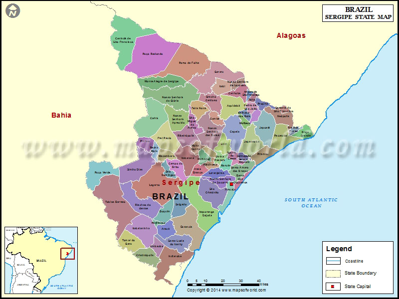
Facts about Sergipe State of Brazil |
|
|---|---|
| Country | Brazil |
| Capital | Aracaju |
| Area | 21,910.348 sq km |
| Population | 2,110,867 Census 2012 |
| Demonym | Sergipano |
| Time zone | BRT (UTC-3), BRST (UTC-2) |
| Postal Code | 49000-000 to 49990-000 |
| Airports | Aracaju International Airport, |
| Website | se.gov.br |
Sergipe is the smallest state in Brazil. It is situated on the northeastern Atlantic coast of the country. Bahia borders the South and western part of the state whereas Alagoas borders the Northern part. Aracaju is the capital and the biggest city of the state. Its inhabitants includes around three-quarters black and mixed race people.
Sergipe is mostly savanna and its coastline is characterized by mangroves, swamps and splendid, sandy beaches. A small section of tropical rain forest runs down the coast. The Sao Francisco River flows against its northern boundary. The southern part of the Brazilian state slopes eastward and is drained directly through a number of small rivers into the Atlantic .There is a sandy belt along the coast line, and the western frontier covers hilly region. The intercede areas are highly fertile, especially in the dense forested land which experiences heavy rainfall. The climate of this state is divided into wet and dry seasons with occasional droughts.
Sergipe’s economy is mainly centered on the sugarcane production.Along with sugarcane, cassava and oranges are being produced over here. Along with it small-scale leather and textiles industry also exists.
The Brazilian federal government is also taking excessive care on the development of a fledgling petroleum and natural gas industry.
The stars on the Sergipe flag represent the number of river estuaries in the state, while the green and yellow stripes symbolize Sergipe’s union. The flag was designed by Jose Rodrigues Bastos Coelho, a noted businessman.
List of Municipalities in Sergipe state of Brazil |
| S.N. | Municipality | S.N. | Municipality |
|---|---|---|---|
| 1 | Areia Branca | 39 | Divina Pastora |
| 2 | Campo do Brito | 40 | Santa Rosa de Lima |
| 3 | Itabaiana | 41 | Siriri |
| 4 | Macambira | 42 | Estância |
| 5 | Malhador | 43 | Indiaroba |
| 6 | Moita Bonita | 44 | Itaporanga d’Ajuda |
| 7 | São Domingos | 45 | Santa Luzia do Itanhy |
| 8 | Lagarto | 46 | Japaratuba |
| 9 | Riachão do Dantas | 47 | Japoatã |
| 10 | Aquidabã | 48 | Pacatuba |
| 11 | Cumbe | 49 | Pirambu |
| 12 | Malhada dos Bois | 50 | São Francisco |
| 13 | Muribeca | 51 | Amparo de São Francisco |
| 14 | Nossa Senhora das Dores | 52 | Brejo Grande |
| 15 | São Miguel do Aleixo | 53 | Canhoba |
| 16 | Poço Verde | 54 | Cedro de São João |
| 17 | Simão Dias | 55 | Ilha das Flores |
| 18 | Tobias Barreto | 56 | Neópolis |
| 19 | Aracaju (State Capital) | 57 | Nossa Senhora de Lourdes |
| 20 | Barra dos Coqueiros | 58 | Propriá |
| 21 | Nossa Senhora do Socorro | 59 | Santana do São Francisco |
| 22 | São Cristóvão | 60 | Telha |
| 23 | Carmópolis | 61 | Carira |
| 24 | General Maynard | 62 | Frei Paulo |
| 25 | Laranjeiras | 63 | Nossa Senhora Aparecida |
| 26 | Maruim | 64 | Pedra Mole |
| 27 | Riachuelo | 65 | Pinhão |
| 28 | Rosário do Catete | 66 | Ribeirópolis |
| 29 | Santo Amaro das Brotas | 67 | Canindé de São Francisco |
| 30 | Arauá | 68 | Feira Nova |
| 31 | Boquim | 69 | Gararu |
| 32 | Cristinápolis | 70 | Gracho Cardoso |
| 33 | Itabaianinha | 71 | Itabi |
| 34 | Pedrinhas | 72 | Monte Alegre de Sergipe |
| 35 | Salgado | 73 | Nossa Senhora da Glória |
| 36 | Tomar do Geru | 74 | Poço Redondo |
| 37 | Umbaúba | 75 | Porto da Folha |

