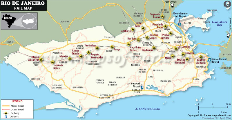
Rio de Janeiro Rail Network
Rio de Janeiro transit system covers the entire city and connects it with the subway, bus, tram, and ferry. The commuter train in Rio has 8 lines and 146 stations covering a rail network of 156 miles (252 km).
- Line Belford Roxo: Central do Brasil ↔ Belford Roxo
- Line Deodoro: Central do Brasil ↔ Deodoro
- Line Japeri: Central do Brasil ↔ Japeri
- Line Paracambi: Japeri ↔ Paracambi
- Line Santa Cruz: Central do Brasil ↔ Santa Cruz
- Line Saracuruna: Central do Brasil ↔ Saracuruna
- Line Vila Inhomirim: Saracuruna ↔ Guapimirim
Rio de Janeiro Metro
The metro system in Rio covers 25 miles (41 km) connecting 35 stations between two lines – Line 1 (9.9 miles) and Line 2 (18.8 miles). While Line 1 (orange line), which runs from Uruguai Station to Ipanema/General Osório Station, serves downtown Rio, some of the neighborhoods in the North Zone, and tourist areas in the South Zone. Line 2 (green line) runs from Cidade Nova in the south to Pavuna in the north.
Rio Light Rail
Also known as VLT Carioca, the Rio Light Rail will be the new addition to the train system in Rio De Janeiro. Once its operations begin in the second quarter of 2016, the 28km-long light rail system will connect the port region of Rio de Janeiro with the financial center and the Santos Dumont Airport.

