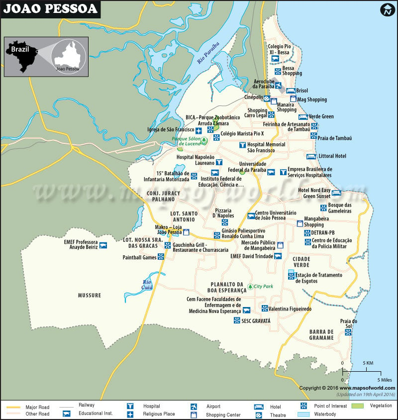
João Pessoa, Brazil
Founded in 1585, João Pessoa – the capital of Paraíba state – is third oldest city in Brazil. Being the easternmost city in the Americas, it is often known as the city where the sun rises first. With nearly 2.7 square miles of urban forests, it is one of the greenest cities in the world. Renowned for beautiful beachfront and historical charm, the city is an offbeat travel destination.
How to Reach João Pessoa
By Air – Presidente Castro Pinto International Airport (JPA) serves the metropolitan area. Shared shuttles are available between the airport and hotels.
By Train – Passenger trains ply between Santa Rita (west) and Cabedelo (north) from the station at Napoleon Laureano Square.
By Road – PB-008, BR230, and BR101 are major highways to access. The city lies 1510 miles northeast of Rio de Janeiro and 1410 miles of the national capital, Brasília. Terminal de Integração is the departure point for local buses.
Things to Do in João Pessoa
Grab a spot by the ocean at the Cabodelo before sundown to hear an orchestral piece by the famous saxophonist Jurandy or admire the exemplary architecture of Estação Ciência, Cultura e Artes at Ponta das Seixas – city’s easternmost corner.
The Centro Histórico (city center) features a day’s worth of sightseeing options. An old gunpowder store and city museum named Casa da Pólvora, history and science museums at Espaço Cultural José Lins do Rego, and central beach neighborhoods such as Tambaú, Manaíra, and Cabo Branco are major tourist attractions in João Pessoa. Museu Sacro e de Arte Popular, housed in the São Francisco church, exhibits a magnificent collection of colonial artifacts. It’s also an amazing lookout point to watch sunset over the forest canopy.
The Parque Arruda Câmara features walking trails, an 18th-century fountain, and a botanical zoo. Lined with palms, Parque Solon de Lucena is a popular city park. Several sandy spots on the 18-mile-long shoreline – from Ponta do Seixas (south) to Cabedelo (north) – are suitable for swimming and surfing. To the north, exotic islands and fishing villages in the estuary of the Paraíba River are idyllic getaways.
| Name | LayerName | Grid Locations |
|---|---|---|
| Empresa Brasileira de Serviços Hospitalares | Hospital Type | A2 |
| Hospital Memorial São Francisco | Hospital Type | A2 |
| Hospital Napoleão Laureano | Hospital Type | A1 |
| Brisol | Hotel Type | A2 |
| Hotel Nord Easy Green Sunset | Hotel Type | A2 |
| Littoral Hotel | Hotel Type | A2 |
| Verde Green | Hotel Type | A2 |
| City Park | Park Type | B2 |
| Parque Sólon de Lucena | Park Type | A1 |
| 15° Batalhão de Infantaria Motorizada | POI Type | A1 |
| Bessa Shopping | POI Type | A2 |
| BICA – Parque Zoobotânico Arruda Câmara | POI Type | A1 |
| Bosque das Gameleiras | POI Type | A2 |
| Centro de Educação da Polícia Militar | POI Type | B2 |
| DETRAN-PB | POI Type | B2 |
| Estação de Tratamento de Esgotos | POI Type | B2 |
| Feirinha de Artesanato de Tambaú | POI Type | A2 |
| Gauchinha Grill – Restaurante e Churrascaria | POI Type | B1 |
| Ginásio Poliesportivo Ronaldo Cunha Lima | POI Type | B2 |
| Paintball Games | POI Type | B1 |
| Pizzaria D`Napoles | POI Type | B2 |
| Praia de Tambaú | POI Type | A2 |
| Praia do Sol | POI Type | B2 |
| SESC GRAVATÁ | POI Type | B2 |
| Shopping Carro Legal | POI Type | A2 |
| Valentina Figueiredo | POI Type | B2 |
| Igreja de São Francisco | Religious Type | A1 |
| EMEF David Trindade | Shopping Type | B2 |
| Mag Shopping | Shopping Type | A2 |
| Makro – Loja João Pessoa | Shopping Type | B1 |
| Manaíra Shopping | Shopping Type | A2 |
| Mangabeira Shopping | Shopping Type | B2 |
| Mercado Público de Mangabeira | Shopping Type | B2 |
| Cinépolis | Theater Type | A2 |

