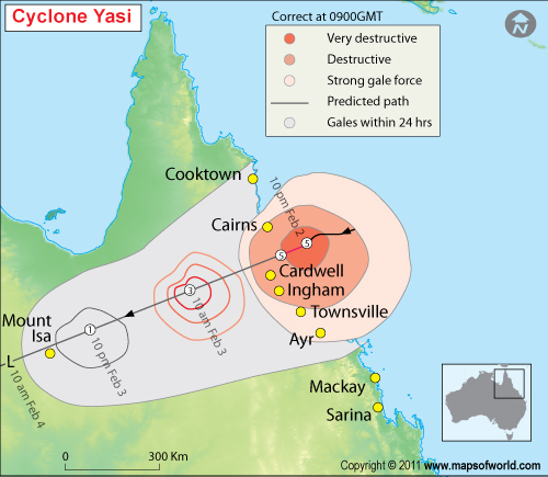
Cyclone Yasi, a category 5 cyclone slammed into the Australia’s northeast coast early on February 3, 2011, with winds stronger than Hurricane Katrina, ripping apart houses and cutting a swath through sugarcane crops, though no deaths have been reported yet. Yasi hit the shore at Mission Beach is a resort town having about 3,000 people, 1,500 kilometers (932 miles) north of Brisbane, the Bureau of Meteorology said. Yasi is the first category 5 cyclone in Queensland since 1918. The cyclone Yasi is being compared to the 2005 hurricane Katrina in USA.
Comparison of cyclone Yasi and hurricane Katrina:
| Cyclone Yasi, February – 2011 | Hurricane Katrina, August – 2005 | |
| Category | Category 5 | Category 4 |
| Landfall | Expected to hit between Innisfail and Cardwell between 10 P.M. and midnight of February 2, 2011 | Louisiana, Mississippi, Florida |
| Size | 500 Km wide | 640 Km wide |
| Eye | 100 Km wide | 51 Km wide |
| Wind Gusts | 320 Km/h | 280 Km/h |
| Storm Surge | Highest point 6.5m – 9m | Up to 8.2 m |
| Rainfall | Estimated 1000mm | Louisiana 380mm, Florida 350mm, Mississippi 250mm |
| Damage | Potentially devastating to buildings | Approximately $91 Billion |
| Death Toll | None recorded yet | 1836 people died |
As Queensland braces for the worst cyclone in living memory, the important websites and phone numbers are:
For SES assistance phone:132 500
For evacuated and concerned residents call the infoline: 1300 993 191
Cyclone evacuation registration: http://www.Redcross.org.au
Far north Queensland evacuation centers
- Woree State School
- Stockland Earlville Shopping Centre
- Redlynch State College
- James Cook University Smithfield
- Trinity Beach State Primary School
- Mossman Community Indoor Sports Centre
- Babinda RSL Hall
- Innisfsail College
Important Websites
- Weather Bureau Cyclone Warnings: www.bom.gov.au/cyclone
- Queensland Disaster Management: www.disaster.gov.au
- Emergency Management Queensland: www.emergency.qld.gov.au
- Cairns Regional Council: www.cairns.qld.gov.au
- Cassowary Coast Council: www.cassowarycoast.qld.gov.au
- Townsville Council: www.townsville.qld.gov.au
- Queensland Government – www.qld.gov.au/cyclone/

