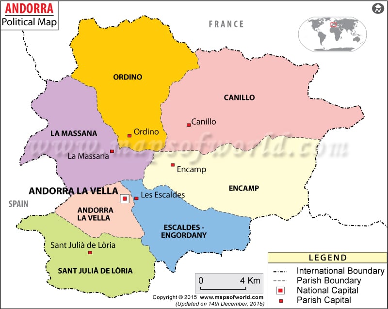
Andorra political map marks the parishes, international boundaries and the capital of the country. The capital is Andorra la Vella. The parishes are Encamp, Canillo, Ordino, Les Escaldes, Sant Julia de Loria, La Massana and Andorra la Vella.
Andorra is located at 42°30’N latitude and 1°30’E longitude. In the map of the country, the international and province boundaries are also indicated.
Location of Andorra
Andorra is a small European country, located in the western part of the continent near to the Eastern Pyrenees mountain range. The country is surrounded by France and Spain.
It is spread over a total of 462 Square Kilometers area. Andorra political map marks all the political divisions of the country. The capital of the nation, Andorra la Vella is marked with red color in the map.
In the printable map of Andorra the major cities are marked with black dot. The cities include:
- Encamp
- Canillo
- Ordino
- Les Escaldes
- Sant Julia de Loria
Andorra Capital
Andorra la Vella is the nation capital. It is located at 42°30’N latitude and 1°31’E longitude. At an altitude of 1409 meters, the capital is situated in the southwestern region of the country in the Parish Andorra la Vella. From the capital of Andorra, the nearest airports are situated in Barcelona, Girona and Perpignan. The airports are:
- Antichan
- La Cerdanya
- Les Pujols
- Seo De Urgel
The major cities and towns which are situated around Andorra la Vella are Llumeneres, Les Escaldes, Santa Coloma, Sispony and Anyos.
| Parish | Population | Area(km.&sup²) | Area(mi.&sup²) | Capital |
|---|---|---|---|---|
| Andorra la Vella | 21,189 | 59 | 23 | Andorra |
| Canillo | 2,706 | 121 | 47 | Canillo |
| Encamp | 10,595 | 74 | 29 | Encamp |
| Escaldes-Engordany | 15,299 | Les Escaldes-Engordany | ||
| La Massana | 6,276 | 61 | 24 | La Massana |
| Ordino | 2,283 | 89 | 34 | Ordino |
| Sant Julia de Loria | 7,623 | 60 | 23 | Sant Julia de Loria |
| 7 parishes | 65,971 | 464 | 179 |

