Zimbabwe Map
 Wall Maps
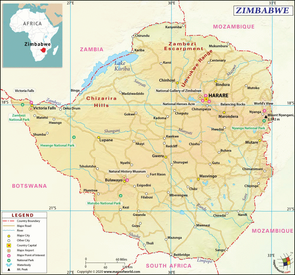
- Neighboring Countries - Botswana, Zambia, Malawi, Mozambique, South Africa
- Continent And Regions - Africa Map
- Other Zimbabwe Maps - Where is Zimbabwe, Zimbabwe Blank Map, Zimbabwe Road Map, Zimbabwe Rail Map, Zimbabwe River Map, Zimbabwe Cities Map, Zimbabwe Political Map, Zimbabwe Flag
About Zimbabwe
Explore this Zimbabwe map to learn everything you want to know about this country. Learn about Zimbabwe location on the world map, official symbol, flag, geography, climate, postal/area/zip codes, time zones, etc. Check out Zimbabwe history, significant states, provinces/districts, & cities, most popular travel destinations and attractions, the capital city’s location, facts and trivia, and many more.
| Full name: | Republic of Zimbabwe. |
| Capital City: | Harare |
| Language: | English, Ndebele and Shona. |
| Currency: | Zimbabwe Dollar |
| Religion: | Syncretic, Christian, Muslim, indigenous religion and others. |
National Anthem: in Shona it is ” Kalibusiswe Ilizwe leZimbabwe”; translated in English, it means ‘Blessed be the land of Zimbabwe’.
• Newspaper: The Sunday Mirror, Zimbabwe Independent, New Zimbabwe, The Zimbabwean and The Herald.
• Places to Visit: Matobo Hills National Park, Victoria Falls, Great Zimbabwe, Lake Kariba, Eastern Highlands, Chimanimani and Gonarezhou National Park.
• Transport: Railways-National Railways of Zimbabwe; Highways; Waterways: Rivers-Mazoe and Zambezi and Ports-Binga and Kariba.
• Shopping: pottery, woven baskets, textile, hand-crafted jewelry and Shona carvings and sculpture.
The Republic of Zimbabwe-formerly called Southern Rhodesia by the British-is situated in the continent of Africa and takes its name from the Shona language. The Shona word for it means “big house of stone”.
Location of Zimbabwe : the Republic of Zimbabwe is situated in the southern region of the African continent, on the Equator. It is uniquely positioned such that some parts of the country fall in the southern hemisphere and some in the north. The countries of Botswana, Namibia, Zambia, Mozambique and South Africa enclose Zimbabwe in a land locked alignment.
Physical Map of Zimbabwe : the one unique feature of the landscape in Zimbabwe is the fact that despite being a landlocked country, it is well fitted out with various land-formations-water bodies included. In fact, the biggest waterfall in Africa-the Victoria Falls-is located right here. The country is mostly plateau oriented-the Mafungabusa plateau; but there are mountain ranges too-the Inyanga and Udizi are the chief of them. The main river providing relief to the land is the Zambesi River. The other water bodies of importance are Lake Kariba, the Limpopo River, the Runde River and the Save River.
Climate of Zimbabwe : since large parts of Zimbabwe lie in the southern hemisphere, the climatic conditions are different. The summer months stretch from October to April and thereafter the winter months continue from May to September. The summers are wet but hot, while the winters are cool but dry.
Flora and Fauna of Zimbabwe : Zimbabwe has quite an incredible biodiversity. However, it contains all the conventional tropical flora and the African fauna. Mostly blanketed with savanna grasslands, its mountains nevertheless consist of evergreen forests. The chief animals of the country are the elephant, lion, buffalo, hyena, cheetah, monkey, jackal and antelope. A diverse variety of marine and avian fauna is also to be found; the tiger fish is a speciality.
Keep surfing Mapsofworld for all the information you need about Zimbabwe Republic and any other place in the world.
