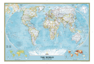
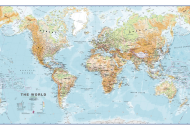
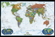
World Map
Maps of World
YOUR WINDOW TO THE WORLD
Buy high quality maps - online!

World Geography Map

World Geography Map
Disclaimer : All efforts have been made to make this image accurate. However Compare Infobase Limited,its directors and employees do not own any responsibility for the correctness or authenticity of the same.

Geography is the scientific study of the earth's surface and the World Geography Map depicts both the earth's physical features and the human phenomena on its surface that is the result of man's interaction with his physical environment. The World Geography map therefore not only shows the distribution of the earth's natural landforms on the surface of the globe but also depicts the elements of human intervention such as political boundaries and the division of the world into countries and independent states together with their capitals and principle cities.

As far as the earth's physical features are concerned, the World Geography Map shows the distribution of the varied natural landforms and topographical features of the earth's surface on a global scale. The spectacular variety of man's natural environment is due to the diverse physical landforms on the surface of the globe ranging from mountains, highlands, plateaus, canyons, valleys, plains, deserts and glaciers to oceans, seas, gulfs, bays, underwater trenches, rivers, lakes, forests, deltas, islands, peninsulas, and coastal landforms such as fiords, coral reefs and capes and promontories. The World Geography Map therefore depicts the main features of elevation and depression on the earth's surface and is also the most graphic representation of the earth's various contours and its most prominent physical features.

The World Geography Map also shows the boundaries separating the various countries and other political entities of the world including their land borders and maritime boundaries. The territorial waters of the countries with coastlines and islands are also clearly marked in the World Geography Map. The division of the world into separate political entities is marked by their political boundaries. Some of such boundaries may be natural such as mountains and rivers while others are politically demarcated. Some of the boundary demarcations are agreed upon by the countries that share those borders and are recognized internationally. But there are some borders that are a subject of continuous dispute. Border disputes may extend over land, water or maritime boundaries and over possessions of such features as watersheds, islands, territorial waters and Exclusive Economic Zones.
Buy this Map Use this map in your Presentations, Internet Sites, Magazines, Print Media, Circulations, Brochures or TV Channel. MapsofWorld.com reserves the right to act against any unauthorized use of its Intellectual Property. All our Financial transactions are through Verisign secure payment gateway.
World Map
World Political Map
World Weather Map
World Climate Map
World Desert Map
Antique World Map
World Map Game
World Continent Map
World War I Map of Europe
World War II Map of Europe
Countries Of The World Map
World Geography Map
World Atlas Map
World TimeZone Map
World Ocean Map
World Religion Map
Ancient World Map
World Travel Map
World Map with Latitude and Longitude
World War I Map
World War II Map
World City Map
Physical Map of the World
Blank World Map
World Map for Kids


Navigation
Home WORLD MAPS WORLD CITY MAPS
WORLD CITY INFO NORTH AMERICA MAPS SOUTH AMERICA MAPS
EUROPE MAPS ASIA MAPS AUSTRALIA & OCEANIA MAPS
AFRICA MAPS USA MAPS WORLD OF SPORTS


WorldMapStore.com An exclusive online store of maps, globes, atlases, travel guides, and CDs.
 World Maps

World Cruises  ||  Honeymoon Destinations  ||  Information on Bosnia