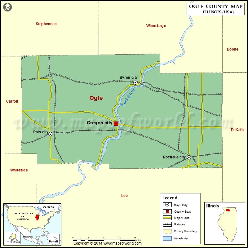
1.5K
Mountain Peaks in Ogle County
| Mountain Peak/Hill | Elevation [Meter] |
|---|---|
| Coffman Bluff | 289 |
| Devils Backbone | 274 |
Airports in Ogle County
| Airport Name |
|---|
| Alcock RLA Restricted Landing Area |
| Bauer Airport |
| Cheechako Airport |
| County Poor Farm Airport |
| Duane E. Davis Airport |
| Eudy Airport |
| Gentry Airport |
| Hammer Airport |
| Maple Hurst Farms Airport |
| Ogle County Airport |
| Reinke Airport |
| Rochelle Community Hospital Heliport |
| Rochelle Municipal Airport – Koritz Field |
| Rock Cut Farms Airport |
| Rummel Restricted Landing Area |
| Sneek Airport |
| Somers Blossom Airport |
| Stillman Fire Heliport |
| Thrifty Acres STOLport |
| West Grove Airport |
Cities in Ogle County
| City | Population | Latitude | Longitude |
|---|---|---|---|
| Adeline village | 85 | 42.140519 | -89.491864 |
| Byron city | 3753 | 42.127326 | -89.262143 |
| Creston village | 662 | 41.933524 | -88.974118 |
| Davis Junction village | 2373 | 42.114341 | -89.08983 |
| Forreston village | 1446 | 42.126526 | -89.578246 |
| Grand Detour | 429 | 41.901088 | -89.413699 |
| Hillcrest village | 1326 | 41.968225 | -89.064585 |
| Leaf River village | 443 | 42.123607 | -89.404066 |
| Lost Nation | 708 | 41.912408 | -89.368985 |
| Monroe Center village | 471 | 42.100118 | -88.994658 |
| Mount Morris village | 2998 | 42.049812 | -89.431132 |
| Oregon city | 3721 | 42.01323 | -89.335604 |
| Polo city | 2355 | 41.98469 | -89.578788 |
| Rochelle city | 9574 | 41.920033 | -89.063473 |
| Stillman Valley village | 1120 | 42.10411 | -89.179978 |
Golf Courses in Ogle County
| Name of Golf Course | Latitude | Longitude |
|---|---|---|
| Edgewood Golf Club-Polo | 41.930814 | -89.542604 |
| Lost Nation Golf Club-Dixon | 41.917468 | -89.384081 |
| Oregon Country Club-Oregon | 42.010618 | -89.317717 |
| PrairieView Golf Course-Byron | 42.105187 | -89.301346 |
| Rochelle Country Club Inc-Rochelle | 41.950502 | -89.064469 |
| Silver Ridge Golf Course-Oregon | 42.057794 | -89.352081 |
| Sunset Golf Course-Mt Morris | 42.052465 | -89.438394 |
 Wall Maps