- Swaziland Cties - Mbabane
- Neighboring Countries - Lesotho, South Africa, Mozambique
- Continent And Regions - Africa Map
- Other Swaziland Maps - Swaziland Map, Where is Swaziland, Swaziland Blank Map, Swaziland Road Map, Swaziland Rail Map, Swaziland River Map, Swaziland Flag
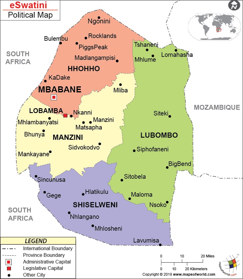
Political Map of eSwatini (Swaziland) clearly shows the provinces, cities and other important locations of eSwatini (Swaziland). It is surrounded by South Africa and Mozambique. Mbabane is the national capital of eSwatini (Swaziland). Its important provinces are Hhohho, Lubombo, Manzini and Shiselweni.
Geographical Position of eSwatini (Swaziland)
eSwatini (Swaziland) Map distinctly shows the geographical location of eSwatini (Swaziland) along with the provinces, provincial capitals and other important cities of this southern African country. eSwatini (Swaziland) is located between South Africa and Mozambique. It falls on the latitude of 26° 30′ South and longitude of 31° 30′ East. The highest and the lowest point of eSwatini (Swaziland) are respectively Emlembe and Great Usutu River.
Mbabane, the capital city
Mbabane, which is the national capital of eSwatini (Swaziland), is located on the geographical coordinates of 26° 18′ South latitude and 31° 06′ East longitude. Some of its nearby cities and towns are Forbes Reef, Darkton, Commissie Nek, Ezulwini and Mhlambanyatsi. It is depicted on the Printable Map of eSwatini (Swaziland) by a red square.
eSwatini (Swaziland) Provinces
The important provinces and their capitals as shown on the eSwatini (Swaziland) Map are as follows:
- Hhohho: Piggs Peak
- Lubombo: Siteki
- Manzini: Manzini
- Shiselweni: HlatikuluSeparate colors have been used for each of the provinces to distinguish one from another.
Cities of eSwatini (Swaziland)
eSwatini (Swaziland) Map also shows the large number of cities that are located in its various provinces. A black dot has been used to symbolize them. Some of these cities are:
- KaDake
- Mliba
- Bhunya
- Rocklands
- Bulembu
- Mhlume
- Maloma
- Nsoko
- Mankayane
- Gege
- Nhlangano
- Lavumisa
Region Population Area(km.²) Area(mi.²) Capital Hhohho 282,734 3,569 1,378 Mbabane Lubombo 207,731 5,945 2,295 Siteki Manzini 319,530 4,070 1,571 Manzini Shiselweni 208,454 3,779 1,459 Nhlangano 4 regions 1,018,449 17,363 6,703

 eSwatini (Swaziland) Facts