- Neighboring Countries - Costa Rica, El Salvador, Honduras, Guatemala, Panama
- Continent And Regions - North America Map, Americas Map
- Other Nicaragua Maps - Nicaragua Map, Where is Nicaragua, Nicaragua Blank Map, Nicaragua Road Map, Nicaragua Rail Map, Nicaragua River Map, Nicaragua Cities Map, Nicaragua Physical Map, Nicaragua Flag
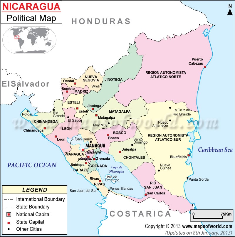
Nicaragua Political Map shows the states, state capitals and cities of Nicaragua. This country is located in Central America in between the countries of Honduras and Costa Rica. The national capital of Nicaragua is Managua.
Nicaragua Location
Nicaragua Political Map shows that this Central American country forms border with the North Pacific Ocean on the western side and Caribbean Sea on the eastern side. It is located between Honduras and Costa Rica. Nicaragua falls on the geographical coordinates of 13° North latitude and 85° West longitude. The area covered by it is approximately 129,494 sq km and the coastline measures 910 km.
States of Nicaragua
There are a large number of states into which Nicaragua is divided. These states can be identified on the Nicaragua Political Map as they are in jet black color. These states are:
|
|
The state capitals have been shown on the Nicaragua Map by white square boxes.
Cities of Nicaragua
The cities can be located on the Printable Map of Nicaragua by black dots. Some of these cities are Wiwli, Eio Grande, Potosi, Muy Muy, La Cruz Rio Grande, Nuevo Amanecer, El Sauce, Nueva Guinea and Punta Gorda.
Managua
The national capital of Nicaragua is Managua, which is located at an altitude of 75 meters above sea level. It falls on the coordinates of 12°09′ North latitude and 86°17′ West longitude. It is highlighted on the Nicaragua Political Map by a red square box.
Nearest Airports: Managua International, Punta Huete, Los Brasiles and Montelimar. Some of the cities and towns located nearby: San Isidro, Ciudad Sandino, El Canton, Miraflores, San Miguel, Colonia Molina and La Argentina.
| Department | Population | Area(km.²) | Area(mi.²) | Zone | Capital |
|---|---|---|---|---|---|
| Boaco | 150,636 | 4,177 | 1,613 | C | Boaco |
| Carazo | 166,073 | 1,081 | 418 | P | Jinotepe |
| Chinandega | 378,970 | 4,822 | 1,862 | P | Chinandega |
| Chontales | 153,932 | 6,481 | 2,502 | C | Juigalpa |
| Esteli | 201,548 | 2,230 | 861 | C | Esteli |
| Granada | 168,186 | 1,040 | 401 | P | Granada |
| Jinotega | 331,335 | 9,222 | 3,561 | C | Jinotega |
| Leon | 355,779 | 5,138 | 1,984 | P | Leon |
| Madriz | 132,459 | 1,708 | 660 | C | Somoto |
| Managua | 1,262,978 | 3,465 | 1,338 | P | Managua |
| Masaya | 289,988 | 611 | 236 | P | Masaya |
| Matagalpa | 469,172 | 6,804 | 2,627 | C | Matagalpa |
| Nueva Segovia | 208,523 | 3,491 | 1,348 | C | Ocotal |
| Region Autonoma del Atlantico Norte | 314,130 | 32,820 | 12,672 | A | Bilwi |
| Region Autonoma del Atlantico Sur | 306,510 | 27,546 | 10,636 | A | Bluefields |
| Rio San Juan | 95,596 | 7,540 | 2,911 | A | San Carlos |
| Rivas | 156,283 | 2,162 | 835 | P | Rivas |
| 17 divisions | 5,142,098 | 130,373 | 50,337 |
 Wall Maps