- Kuwait Cities - Kuwait
- Neighboring Countries - Iraq, Saudi Arabia, Iran
- Continent And Regions - Asia Map
- Other Kuwait Maps - Kuwait Map, Where is Kuwait, Kuwait Blank Map, Kuwait Road Map, Kuwait River Map, Kuwait Physical Map, Kuwait Flag
Kuwait is a Middle East country, and the history of the country can be dated back to 1613 CE. In Kuwait constitutional monarchy prevails. Emir or Sheikh is the head of the country, who appoints the Prime Minister of the country.
The country is divided into six governorates. The country is highly industrialized and the major portion of the country’s economy depends on oil industry.
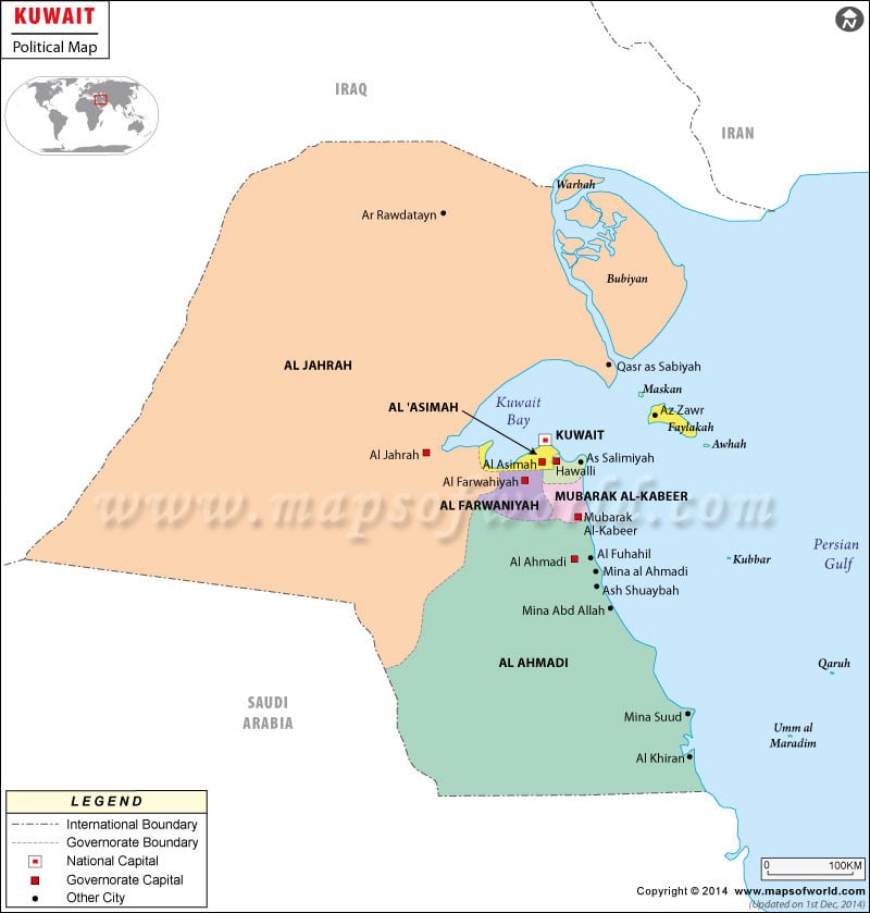
Political Kuwait Map
Kuwait is located in Middle East officially known as the State of Kuwait. The geographical coordinates of Kuwait are 29° 30’North latitude and 45° 45′ East longitude. The total area covered by the country is 17,820 square kilometers. The population of Kuwait as per the census of July 2007 was 2,505,559. The official language of Kuwait is Arabic, while English is also spoken by many people of the country. In the political map of Kuwait, the international and domestic boundaries, built up area, national capital, capitals of the districts and major cities have been clearly pointed out.
Kuwait Capital
The capital of Kuwait is Kuwait City. The geographical coordinates of Kuwait City are 29° 22′ 11″North latitude and 47° 58′ 42″East longitude. The capital of Kuwait is marked in the political map by a red star. The altitude of the city is 19 feet. Some of the nearby airports of Kuwait City are Kuwait International, Ahmed Al Jaber Ab, Ali Al Salem ab and Udairi Aaf. Some of the cities that are in the close proximity to Kuwait are:
- Ash Sharq
- Al Qiblah
- Al Murqab
- Umm Siddah
Kuwait Boundaries
The countries surrounding Kuwait indicated in the political map of Kuwait are Iran to the eastern side, Iraq to the western and northern side and Saudi Arabia. Kuwait Bay is located in the eastern portion of the country.
Kuwait Cities
The major cities of the country have been highlighted in the printable map of Kuwait by black dots. Some of the major cities, which are indicated in the map, are:
- Mina Suud
- Al Khiran Qasr
- Mina Abd Allah
- Al Fuhahil
- Mina al Ahmadi
- Ash Shuaybah
- Al Abrah
- Ar Rawdatayn
Kuwait District capitals
The capitals of the district of Kuwait are depicted in the map of Kuwait by using green boxes. The internal boundaries of the districts are also pointed out in the printable map of Kuwait by colored lines. The indicated district capitals in the political Kuwait map are:
- Al Ahmadi
- Al Farwahiyah
- Al Jarah
- Al Kuwait
Kuwait Other Locations
In the political map of Kuwait, some areas are built up. The built up areas of Kuwait have been highlighted by a specific shade of color. The places, which are included in the built up areas of the country, are Hawalli, Al Kuwait, Al Jarah, and Al Farwahiyah.
| Governorates | Population |
|---|---|
| Al Ahmadi | 313,424 |
| Al Farwaniyah | 498,584 |
| Al Jahrah | 252,157 |
| Al Kuwayt | 305,694 |
| Hawalli | 496,245 |
| Mubarak Al-Kabir | |
| 6 governorates | 1,866,104 |

 Kuwait National Day