1.5K
- Continent And Regions - Africa Map
- Other Sao Tome Principe Maps - Sao Tome Principe Map, Where is Sao Tome Principe, Sao Tome Principe Blank Map, Sao Tome Principe Road Map, Sao Tome Principe Cities Map, Sao Tome Principe Political Map
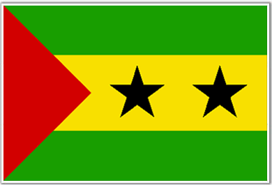
The flag of Sao Tome Principe , although in pan-African colors is modeled on the flag of the Liberation Movement. The only difference is that the flag of Liberation Movement has equal horizontal stripes.
The red triangle in the Sao Tome Principe flag represents the hard-fought struggle for independence of the people. The two black stars symbolize the two main islands of the country. Green, yellow and black are pan-African colors. The central yellow stripe is 1.5 times broader than the green stripes.
| Official Name: | REPUBLICA Democratic de Sao Tome e Principe |
| Capital: | Sao tom |
| Location: | an island nation in the gulf of Guinea made up of the volcanic islands of Sao Tome Principe Pedras tinhosas and Rolas. |
| Area: | 1001 Sq. km. |
| Official Languages: | Portuguese |
| National Flag: | 3 horizontal stripes of green yellow green with the yellow of double width and bearing two black stars in the hoist a red triangle over all. |
| National Anthem: | Independencia Total Total independence (1975) |
| National symbol(s): | palm tree |
| National colors: | green, yellow, red, black |
| National anthem: | |
| Name: | “Independencia total” (Total Independence) |
| Lyrics/Music: | Alda Neves DA GRACA do Espirito Santo/Manuel dos Santos Barreto de Sousa e ALMEIDA |
Fact about Sao Tome and Principe flag |
| Country | Sao Tome and Principe |
|---|---|
| Designed by | NA |
| Adopted | 5. November 1975 |
| Revision | NA |
| Design and Colors | A horizontal tricolour of green, yellow and green; with a red triangle based at the hoist and two black five-pointed stars in the yellow stripe |
| Size Ratio | 1:2 |

 Sao Tome Principe Distance Calculator and Driving Directions