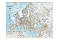
About the Europe Political Map
This Europe Political Map depicts the geographical boundaries of all the European countries, along with their national capitals, and other primary cities. Country capitals are noted in red, and the international borders of all 50 sovereign states, and five with limited recognition, that make up Europe are shown on the Europe Map. Covering about 2% of the earth’s surface, Europe is the second smallest continent in the world, with a total area cover of 3.93 million square miles.
The Cultural, Historical and Political Diversity
Firmly rooted in architecture, art, literature, music, and philosophy, the culture of Europe is highly diverse. With more than 741.45 million people living in Europe 2016), there are eight ‘major’ groups of people which account for 65% (481.94 million) of the European population. These include Russians, Germans, French, British, Italians, Spanish, Ukrainians, and Poles. These countries are represented on the Europe Political Map. However, there are hundreds of cultural minorities present all over Europe.
Ever since the early stages of modern history, European culture has seen an unprecedented growth, and an ever-increasing political and cultural influence. From great prehistoric civilizations like Minoans and Mycenae (2700–1100 BC), to the highly influential modern states of the UK or Germany which are shown on the Europe Map, every civilization and time period has helped add to the cultural, historical, and political diversity of Europe.
Facts
With a total population of over 740 million, the continent of Europe covers a total area of 3,930,000 square miles (10,180,000 square kilometers). Russia is the largest country in Europe with a total area of 6,592,800 square miles (17,075,200 square kilometers) as seen in the Europe Political Map. It is also home to the highest point in Europe (Mt. Elbrus, Russia 5,633 meters), the longest river in Europe - the Volga, in Russia, is 2,294 miles long (3,692 kilometers) as well as the largest lake in Europe – Ladoga, Russia, at 6,834 square miles (17,700 square kilometers).
Vatican City is the smallest country of this continent, with the total area of nearly half a square kilometer (look at the box provided in the Europe Map). The lowest measurable point on the continent of Europe is the Volga Delta in the Caspian Sea, situated 92 feet (28 meters) below the sea level.
| Area | 3,930,000 square miles (10,180,000 square kilometers) |
| Estimated Population | 740 million |
| Highest Point | Mt. Elbrus, Russia (5633 meters) |
| Lowest Point | Volga Delta, Caspian Sea (-28.0 meters) |
| Longest River | The Volga - Russia - 2,294 Mi (3,692 kilometers) |
| Largest Lake | Ladoga - Russia - 6,834 mi² (17,700 square kilometers) |
| Largest Country | Russia - 1.54 million square miles (4 million square kilometers) of Russia are in Europe) Ukraine is the largest country entirely in Europe - 233,000 square miles) (603,500 square kilometers) |
| Smallest Country | Vatican City - 0.17 square miles (0.44 square kilometers) |
Major Countries
Each and every country in Europe has much to offer. The geographical and cultural diversity attracts tourists to every part of the continent. The five most-visited countries are; France with 86.9 million foreign visitors, Spain with 81.8 million foreign visitors, Italy with 58.3 million foreign visitors, the United Kingdom with 37.7 million foreign visitors, and Germany with 37.5 million foreign visitors (Schengen visa, 2018).
France, Germany, Italy, and the UK are widely known as the 'Big Four' (G4 or EU4) because of their economy and are clearly marked on the Europe Political Map.
Modern Europe
Modern Europe as seen in the Europe Political Map has evolved after a long history of conflict and strife such as the two World Wars, disintegration of Russia, building and dismantling of the Berlin Wall among many others. It has also played a pivotal role in how the world perceives arts, literature, science, and technology. Home to some of the most influential thinkers and artists of our time, Europe has produced individuals who have consistently triumphed in nearly all fields of arts, exploration, and research. Some of notables are; Christopher Columbus, Galileo, Newton, Einstein, Socrates, Plato, Aristotle, Leonardo da Vinci, Raphael, Michelangelo, and more.
Europe is also the home of the age of renaissance, exploration, trade, reformation, mercantilism, and colonial expansion. All these time periods made Europe, the second smallest continent in the world, perhaps the most influential all over.
Europe’s influence and impact, positive or negative, grew exponentially. The rise of the Industrial Revolution was first seen in Europe, and helped revolutionize the fields of manufacturing, production, transportation, and agriculture. It also provided the common Europeans a considerable advantage over the rest of the world, giving rise to European colonialism.
Important Travel Destinations (Things to Do and Places to Visit)
Europe has some of the most alluring and diverse cities in the world. Whether it is sipping French wine while admiring the magnificent Eiffel tower in Paris, enjoying a nice cup of English tea in London, shopping in the overwhelming Grand Bazar in Istanbul, or learning the history of great modern civilizations like the Romans and Greeks, there are countless places to visit and things to do in Europe.
From ancient wonders like Stonehenge in Wiltshire England, and the Colosseum in Rome, Italy, to modern engineering and technological marvels like Millay Viaduct (Millau, France), or The Venice Tide Barrier Project (Venice, Italy), the continent of Europe is a heaven for travelers and explorers from all over the world. The cities discussed above are located in the Europe Political Map.
History Maps of Europe
Here is a list of all the European Countries